|
MAIN
PAGE
CHAPTER I CHAPTER II CHAPTER III CHAPTER IV CHAPTER V CHAPTER VI CHAPTER VII CHAPTER VIII CHAPTER IX CHAPTER X CHAPTER XI CHAPTER XII |
|
MAIN
PAGE
CHAPTER I CHAPTER II CHAPTER III CHAPTER IV CHAPTER V CHAPTER VI CHAPTER VII CHAPTER VIII CHAPTER IX CHAPTER X CHAPTER XI CHAPTER XII |
THE CAUSE OF THE ICE EPOCH is a pivotal subject in the study of astral
catastrophism. Once the nature and scope of the ice cataclysm is perceived,
then astral catastrophism is easily recognized, and geophysical consequences,
as they apply to Earth history, become apparent.
There have been at least two icy catastrophes in our solar system. One involved the region of Saturn; the other involved the region of the Earth. The circumstance of the icy rings of Saturn is important because this may help establish a clue as to the nature of the Earth's Ice Epoch.
The rings of Saturn were originally considered to have been composed of rock-like fragments, similar to the composition of the asteroids or meteor streams. But in 1948, Gerard Kuiper measured the thickness of the rings of Saturn. They were already known to be about 41,500 miles in breadth and about 171,000 miles in diameter. There were three primary rings involved of varying widths up to 16,000 miles.1
Kuiper was surprised to find that the rings were only 10 miles thick. He was aware of the albedo or reflectivity of Saturn's rings. He immediately concluded that because rock fragments could not reflect as much light as the rings did, they must be rings of ice. Now it is generally accepted that the rings of Saturn are composed of icy particles. They are water in the solid state merely because of their great distance from the sun, and the resultant low temperature. No one knows exactly how much ice is involved in Saturn's rings. Relative to the planet Saturn, the amount of ice involved in her rings is rather negligible. Spread out evenly across her 16 billion square miles of surface, it would be of almost no consequence.
However, from the perspective of the Earth, the reverse is true. The Earth is about 100 times lighter than Saturn, and has about l/80th of the amount of the surface of Saturn. From the Earth's perspective, there is a good deal of ice in Saturn's broad rings--enough, say, to initiate a pretty good-sized ice epoch.
The rings of Saturn are entirely within the critical distance involved in Roche's limit concerning an astral fragmentization.2 If the material of the fragmentized body were in the solid state rather than the liquid, the gravity of the planet would prevent the coalescence, and the fragments would remain in orbits about the planet in accordance with Kepler's laws. Therefore, the origin of Saturn's rings must have been from some icy astral visitor which got too close and disintegrated under the influence of Saturn's immense gravitational field.
Are there many icy astral bodies in our solar system? Jupiter, Saturn, Uranus, and Neptune--the four major planets in our solar system--are composed of much ice (some astronomers say mostly of ices and hydrogen). Ganymede, one of Jupiter's moons, is considered to have a rock core and an ice crust. Io and Europa probably are composed of rock, like our moon. Callisto, some feel, is almost pure ice. Several of Saturn's satellites, like Saturn, are also presumed to be composed mostly of ice.3
The (1) origin of the ice in Saturn's rings seems to have been either within or beyond our solar system, from the cold and remote regions of the galaxy. The ice probably (2) approached Saturn via an orbit of substantial eccentricity, and the (3) depositing of the ice around Saturn must have been a response to the physical laws governing fragmentized particles.
Any acceptable theory of the Ice Epoch for our Earth must also adequately explain these three features: (1) the origin of the ice; (2) the method or mode of transportation of the ice; and (3) the particular location of the depositing of the ice. Although there have been numerous ideas and suggestions about the cause of the Ice Epoch which at one time engulfed our planet, all of the well-known ones have stemmed from uniformitarian thought.
These theories of glaciogenesis are woven around nine major themes:4
1. A decrease in solar radiation.2. The passing of the Earth through cold regions in the universe.
3. An increased eccentricity of the Earth's orbit.
4. Variations in the amount of carbon dioxide in the atmosphere.
5. Variations in the directions of high-latitude ocean currents.
6. Variations in the relative proportions of land and water.
7. Variations in the angle of the axis to the plane of the ecliptic.
8. Changes in the location of the geographical poles.
9. Shifts in elevation of land areas relative to sea level.
It will suffice to merely point out that all nine themes embrace
certain assumptions relative to (1) the origin, to (2) the mode of transport,
and to (3) the location of the final deposition of the ice. All theories
assume the origin was water vapor which had risen by evaporation from the
Earth's oceans in lower latitudes. All theories assume that the method
of transport was via clouds and planetary wind systems. And lastly, all
theories consider that snow fell in the glacially affected areas because
of the high latitude and the cold climate. These three basic assumptions
are integral with Lyell's 19th century uniformitarian hypothesis.
All uniformitarian approaches presumed that snow fell unendingly over
vast spans of time. Lyell first taught that the ice age ended about 1,000,000
B.C., but when it was later brought to his attention that Niagara Falls
could be used as a crude natural chronometer of the ice epoch, he acknowledged
96% of the 99% dimension of his error. Since Lyell's day, a considerable
volume of data has accumulated, reflecting further requirements. Following
is a brief review of some ice circumstances and conditions. They involve
requirements which any good hypothesis on Ice Epoch origin (glaciogenesis)
must accommodate.
1. The Frozen Mammoths: An Illustration of Sudden Freezing
| Mammoths were, along with mastodons, the largest members of the elephant
family. They have become mummified in two manners, both of which suggest
cataclysm and suddenness. In Alaska and Siberia mammoths have been mummified,
apparently by the millions, both in ice and in sedimentary strata. It is
as if they had been deposited in watery graves in some areas, but encased
in ice in other areas, ice which has remained un-melted. Their entombment
and refrigeration have been so effective that mammoth carcasses have been
thawed to feed sled dogs, both in Alaska and Siberia; in fact, mammoth
steaks have even been featured on restaurant menus in Fairbanks.
Every indication is that the mammoths died suddenly, in intense cold, and in great numbers. Death came so quickly that the swallowed vegetation is yet undigested in their stomachs and their mouths. Grasses, bluebells, buttercups, tender sedges, and wild beans have been found, yet identifiable and undeteriorated, in their mouths and stomachs.5 What dropped the mammoths with such suddenness and such unearthly cold? |
|
The excavations of Pompeii have revealed how swiftly the fleeing victims were asphyxiated, and promptly buried. In the case of the mammoths, the span of time between death and freezing can be estimated quite accurately through an examination of the carcasses. This is determined by the extent of water separation within the cell, for water begins to separate within the cell at death, and it ceases to separate at freezing. The small extent of separated water indicates that carcasses were frozen rapidly, perhaps at temperatures below -150° F.7
Temperatures of this severity exist in our solar system, but not at the surface of the Earth. These temperatures exist, for example, among the frozen atmospheres of Jupiter and her icy satellites such as Callisto, Ganymede, Io and Europa. These temperatures exist among the icy crust of Saturn and her icy rings, along with such satellites as Iapetus, Rhea and Titan, to say nothing of Uranus and Neptune. If icy particles in temperatures nearing -200° F. were deposited upon the Earth from such an astral visitor, this could produce a great, icy avalanche of supercooled ice, possibly reproducing the supercooled conditions under which the mammoths so suddenly met their death. Under these conditions, even a huge, woolly mammoth would immediately perish, not to mention sheep, camels, rhinoceroses, bison, and other animals which have similarly been found encased in ice. They perished immediately by asphyxiation because, at these temperatures, their lungs were frozen solid. They dropped immediately, and death ensued very shortly.
Concerning the perishing of the mammoths, the uniformitarian approach has been non-plussed, and has had no explanation. The same applies to quick-frozen rhinoceroses, sheep, horses, oxen, lions, tigers, bison, and numerous other animals.8
Wrangell, the explorer, observed on Bear (Medvizhi Ostrova) Island that the soil consisted of only sand, ice, and such a quantity of mammoth bones that they seemed to be the chief substance of the island. On the Siberian mainland, he observed that the Siberian tundra was dotted more with mammoth tusks than with Arctic shrubbery.9
Pallas related that there was not a riverbed in all Russia or Siberia, from the Don to the Bering Strait, which did not contain bones of elephants and other animals.10 It has been recorded that during two consecutive decades (1880 to 1900) at least 20,000 elephant tusks were taken from one single Siberian ivory mine. Ivory trade from Siberia has had a long history, as old as the recorded annals of the area.11 Traditions of Siberian ivory are at least as old as the historians of the Roman Empire.
The long series of astounding finds of icy carcasses are too voluminous
to relate here. The findings of Howorth, Nelson, Rehwinkel, Sanderson,
and Vail are notable. But the important thing is that an adequate explanation
is needed, and furthermore, an adequate explanation should be possible.
The slow snow theory intrinsic to uniformitarianism is wed to the notion
that climatological bases contain the explanation.12
In the catastrophic theory, however, the climatological approach with its
various complications, is bypassed, allowing for an entirely new basis
to explain the suddenness, the extremeness, the source of the ice, the
simultaneous condition of icy and watery graves, and other related phenomena.
This icy catastrophe was a great event in Earth history, and it was an
historical event (rather than a scientific event). Some scientists may
say that this sort of icy and watery catastrophe couldn't happen; the theory
set forth here suggests that it did.13
2. The Regions of Sudden Chilling
The regions of sudden chilling occurred in both hemispheres, and mostly in the high latitudes (high latitudes relative to both the geographical poles and the magnetic poles). In Antarctica, less than 200 miles from the South Pole, Byrd found evidences of a former warm and humid climate which nurtured luxuriant forests.14 On the island of Spitsbergen (Svalbard), palm leaves ten and twelve feet long have been fossilized, along with fossilized marine crustaceans--which could only inhabit tropical waters. This suggests that at one time the temperatures of the Arctic Ocean were similar to the contemporary temperatures of the Bay of Bengal or the Caribbean Sea. Spitzbergen is half way between the northern tip of Norway and the North Pole, at a latitude of 80° N. Today, ships can reach Spitzbergen through the ice only about two or at the most three months during the year. And in the New Siberian Islands (slightly warmer than Spitzbergen at a latitude of 75° N.), explorers claim to have found species of tropical plants encased in ice, as were the mammoths. How could this be? Were explorers spinning yarns?
Antarctica, Spitzbergen, and the New Siberian Islands are but three
places where evidences occur that coldness came with extreme suddenness,
wiping out a previous tropical climate with a finality that has lasted
over many thousands of years. This directly leads to two queries: First,
what caused the abrupt change which so dramatically froze the fauna and
flora?15
And secondly, and probably more important, what was the nature of the previous
climate? This second question will be dealt with in Chapter IX, and the
reasons will be given as to why an answer to this question ultimately may
be the more significant. Meanwhile, the immediate question is, what happened?
Was this sudden coldness natural or unnatural, seasonal or unearthly? Uniformitarianism
is hard-pressed to produce a satisfactory answer.
3. The Depth of the Ice Mass
The suddenness of the onset of the Ice Epoch has been briefly considered,
relative to both hemispheres. The evidences are amazing and phenomenal.
Of no less import, and of no less amazement, is the depth to which ice
occurred. Sudden frost and extremely cold air are one thing; ice in depth
is another thing. What was the depth of the ice mass in the Northern Hemisphere,
or in the Southern Hemisphere?
|
|
It has been established, from the direction of ice flows, studies of
gradients, distances, and other related data, that there were several nodes
of ice on the Canadian Shield. It has further been established that the
depth of ice at these nodes was between 15,000 and 17,000 feet.
In the Southern Hemisphere, a comparable circumstance apparently existed. In 1958, an ice core was taken on the Antarctic Ice Cap near Byrd Station. Drilling commenced at an elevation of 5,000 feet above sea level. The thickness of the ice sheet was 10,000 feet, and the drill went through solid ice all the way. This means that ice is not only situated 5,000 feet above sea level in the Antarctic Region; it is also resting on terra firma some 5,000 feet below sea level.16 How is this explained? Traditional uniformitarian thought has it that snow fell over unending epochs until ice was built up to 10,000 or 15,000 feet, after which it suddenly began to flow and/or melt faster than the rate of buildup. This is difficult to accept, for numerous reasons. For instance, uniformitarians must maintain that falling snow accomplished this both at elevations of 17,000 feet above sea level and 5,000 feet below sea level, and in both the fluid atmosphere and in the fluid ocean. Is this what we are to believe? |
On the other hand, if it is believed that ice, descending from outer space at a superrefrigerated temperature around -200°F., caused the sudden and extreme change in atmospheric temperatures, then the sudden asphyxiation and freezing of the mammoths becomes logical. Similarly, the stacking up of ice in nodes 10,000 to 15,000 feet deep becomes conceivable. Furthermore, if this is a period of simultaneous gravitational and magnetic conflict, with tides alternately 5,000 and 10,000 feet both above and below mean sea level, then formations including ice deposits could well occur below mean sea level. And apparently this is what happened, for ice does rest on bedrock some 5,000 feet below sea level, and it has had enough coldness to overcome both the heat of oceanic melting and the heat of internal pressure. This similarly checks with mammoth fossils engulfed in ice but also in alluvium.
At this point, a further parallel needs to be seen. In the previous chapter it was pointed out that mountain uplifts, global in scope and scallop-like in alignment, traversed both continental massifs and oceanic basins with equal ease. Somewhat similarly, it seems, ice masses of vast dimensions were deposited in high latitudes (relative to both geographical and magnetic poles) indifferent to and irrespective of whether the particular area was an oceanic basin or a continental massif. This parallelism relative to orogenesis and glaciogenesis must not be overlooked.
Three perspectives of the Ice Epoch have thus far been noted: (1) The
suddenness in timing, with the mammoths as the prime illustration; (2)
The regions in location, with Antarctica, Spitzbergen and the New Siberian
Islands as illustrations; and (3) The depth of the ice mass, with both
the Canadian Shield and the Antarctic Shelf serving as illustrations. The
depth of the ice on the Canadian Shield was approximately 3 miles; presumably
it was originally of a similar depth on the Antarctic Continent. Next let
us briefly consider the volume of ice involved.
4. The Volume of the Ice Mass
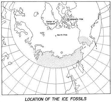
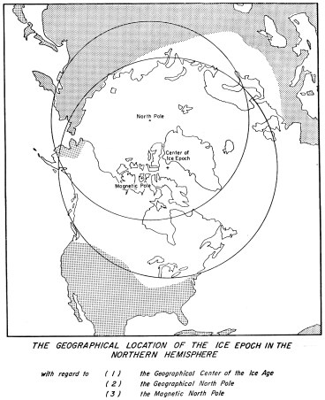
The ice mass is pretty well traced in the Northern Hemisphere since there is a prevalence of land at high magnetic and geographical latitudes--Asia, Europe, and North America. The ice mass extended from Eastern Alaska to Central Europe, and from the fringes of Siberia to the Central United States. Figure 14 illustrates the region involved. Note that while it is located largely in high latitude areas, it is nevertheless eccentric in location to the North Pole, but is more central to the Magnetic North Pole.
The diameter of the breadth of the ice mass was between 5,000 and 5,200 miles. The area it covered was about 17,000,000 square miles. It is equal to all of the land surface in the Western Hemisphere, including both Americas and their offshore islands. Or, on the other hand, it is equal to the continent of Asia in its entirety.
This was the area involved in the Northern Hemisphere. Presumably a nearly equal amount of ice descended in the Southern Hemisphere also. Certainly such far removed locations as Southern Chile, New Zealand, Antarctica, Tasmania, and the Kerguelen Islands indicate abundant evidences of a similar history.
The ice was approximately 3 miles deep in its central nodes, and it feathered out toward the edges. On the basis of conic volumes, the volume of the ice in the Northern Hemisphere is estimated at about 6,000,000 cubic miles. Probably a like amount was deposited in the Southern Hemisphere. This volume can be compared against the post-diluvian rise in sea level, as measured on the continental shelves. The recent rise was between 350 and 450 feet. This was a result of the melting of the ice in the Ice Epoch. The two methods of figuring the volume of the ice check out quite well.
Thus the estimate of the ice involved in the Ice Epoch in both hemispheres is between 12,000,000 and 14,000,000 cubic miles. This is a lot of ice to account for, by Earth's standards. Furthermore, here is a lot of heat transfer to explain and a lot of area as well as a lot of elevation to explain, whether above or below sea level.
The volume of heat required to reduce 12,000,000 cubic miles of water from 70° F. to below freezing and turn it into ice exceeds 3 septillion calories. This is enough heat to reduce many Earth atmospheres to absolute zero. Or in another perspective, this is enough heat loss to freeze 400 cubic feet of ice for every square foot of surface of the Earth. Imagine 400 blocks of ice, stacked vertically, for each square foot of Earth surface. This is the order of magnitude of heat exchange which somehow must be explained.
Thus far, we have discussed coldness and ice with regard to (1) suddenness
of timing, (2) regions in location, (3) depth of ice, and (4) volume of
ice and the magnitude of heat exchange. Twelve million cubic miles of ice
is a great deal to explain. Let us now consider the geometrical shape of
the ice formation.
5. The Geometry of the Ice Mass
Any acceptable theory on the ice mass must accommodate itself to the geometry of the ice formation. There were several nodes on the Canadian Shield, from 15,000 to 17,000 feet in elevation, generally about 3 miles deep at these apexes. From these areas, the ice flowed outward in a radial pattern and in every direction, corrected only by coriolis forces or local topographical features. It flowed over hills hundreds and even over a thousand feet high, and swept on over valley and dale for hundreds of miles. As it flowed, it gathered rocks, timber, and other debris which were ground and ultimately dropped at its edges, forming lateral and terminal moraines. The extent of the ice flow is determined from and orthogonal to the terminal moraines; the direction of the flow was parallel to such formations as drumlins and the lateral moraines. The path of flow is also plotted by locations of erratic boulders, striations and other methods.
According to uniformitarian theory, the ice was supposedly formed by snow, which had been transported by wind systems from moist, warm regions. The snow was to have fallen for many eons, until conditions changed and the processes of buildup were exceeded by the processes of out-flow and melting. This hypothesis does not agree with the manner of the flow of the ice mass; neither does it agree with the direction of the ice flow.
Perhaps the best illustration is found in the coldest area of the Earth, Interior Antarctica, where snow does not fall in great amounts; in fact, Interior Antarctica ranks along with the interior of the Sahara Region in precipitation.17 It is rather at the fringes of Antarctica where substantial snows occur, for this is the region where warmer and more humid maritime air mixes with the cold, dry, interior air. A similar condition occurs in the Northern Hemisphere. The regions of abundant snowfall are mostly at maritime locations on the Arctic peripheries where warm maritime airs mix with cold Arctic airs. A saucer-shaped pattern for snowfall occurs in the Northern Hemisphere. Though more irregular, it is nevertheless similar to that in the Southern.
If falling snow is to have been the cause of the ice mass, it would be logical to presume that ice would be deepest where the snowfall was the greatest. There would be a thicker accumulation at the edges than at the interior or center where little humid air would penetrate. But geology has revealed that the ice mass was conical in geometrical shape, not saucer-shaped.
Furthermore, the pattern of ice flow also does not agree with the uniformitarian hypothesis. Today there are slow-snow glaciers in the mountains along the Pacific Ocean in Alaska, British Columbia, Washington, and Oregon, which flow in a riverine pattern, avoiding the hills and ridges and concentrating in the valleys. But the flow of ice, following its deposition in the Ice Epoch, was largely oblivious to topography until the flow feathered out at the fringes. In the more central portions, it flowed en masse over hills hundreds and thousands of feet high with seeming indifference. This is a radial pattern of flow.
A radial pattern of flow occurs when material flows outward in all directions from the center until a new equilibrium is established. This occurs, for instance, when honey is poured on bread, when milk is spilled on the table, or when pancake batter is dropped onto the griddle. Such events are sudden which cause radial patterns of flow. Gradual events cause riverine patterns of flow. The radial pattern of flow of ice from the Ice Epoch is another evidence of sudden accumulation. The illustration of the freezing of the mammoths was given to portray sudden chilling of the atmosphere; this was simultaneous with the sudden descent or dumping of great masses of ice (great volumes by Earth's standards) upon the high latitude regions.
Thus far we have considered the following features of an adequate theory
of glaciogenesis: (1) suddenness in timing; (2) regions in location; (3)
depth of ice; (4) volume of ice and the magnitude of heat exchange; and
(5) geometry of the ice mass and the radial pattern of flow. Let us now
consider the eccentric location of the ice mass in the Northern Hemisphere.
6. The Eccentric Location of the Ice Mass
Figure 14 illustrates that the ice mass, rather than having been centered on the North Pole or on the Magnetic North Pole, was considerably closer to the Magnetic Pole than the Geographic Pole. Moreover, there is reason to suspect that the Magnetic Pole has migrated in post-diluvian times, having once been located in the area between Northern Baffin Island and Northwestern Greenland.
Uniformitarian hypotheses have invariably suggested that the ice mass was located in the high latitudes because that is where the climate is coldest, and where there is minimum solar radiation. This explanation fails, however, to account for the observed eccentricity in the location of the ice mass.
| Notice that the ice mass appears to have missed almost all of Siberia,
excepting the offshore islands. This is the coldest portion of the Northern
Hemisphere in our age. Notice also that it spread out over the Central
States down to the 37th latitude. This is more than half way to the equator.
Illinois is about 500 miles closer to the Magnetic North Pole than is Northern
Siberia. People in rural Illinois get a much better view of the Northern
Lights (Aurora Borealis) than do Siberians, because they live closer to
the Magnetic North Pole.
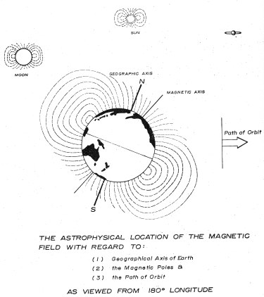
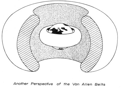
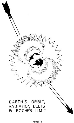
In noticing the location of the Aurora Borealis in association with the location of the ice mass, we must remember that sometimes in geography associative relationships are as meaningful as "cause and effect" relationships. The Aurora is related to the Van Alien Belts (see Figures 15 and 16) and the magnetic poles. During periods of sunspot activity, charged particles are emitted from the Sun and interact with the Earth's magnetic field. They are shunted around the magnetic field at high velocities; they are deflected, essentially by the magnetic field of the Earth. They tend to converge over the magnetic poles, and collide with atmospheric particles in the ionosphere. These collisions produce electrical changes which, in their ethereal brilliance, are termed Northern Lights. In losing velocity, the particles begin to descend. |
|
|
|
It is our supposition that the location of the ice mass--an important factor in the astral-gravitational-magnetic catastrophe --was dependent more on the magnetic axis than the geographical axis. There seems to be a relationship, as yet not understood, between the geographical axis and the magnetic axis. However, had the magnetic poles been located in tropical climates, it is suspected that the ice mass would also have occurred in tropical climates. Therefore, the ice mass which descended largely in high latitudes offers no strength to the uniformitarian proposition, for the Arctic Circle and the Ice Epoch peripheries are eccentric to each other. The only coincidence between the two areas lies in the fact that the geographic and magnetic poles coincide within about 1200 miles of each other. |
7. The Ice Cave Phenomena of Eastern Washington
It has been demonstrated that similar arcuate mountain patterns occur with equal boldness on both the Earth and her satellite. It has also been demonstrated that arcuate mountain patterns traverse both continental massifs and oceanic basins, and andesitic or basaltic regions with seemingly equal ease. It has similarly been demonstrated that immense deposits of extremely cold ice have occurred in magnetic polar regions, both on continental massifs (the Canadian Shield) and on the bedrock beneath oceanic areas (the Antarctic Shelf), also with seemingly equal ease.
Consider now yet another phenomena, namely ice sandwiched between layers of lava rock. Sedimentary rock is water-lain and usually considered as having been formed under moderate temperatures. Igneous rock is usually considered as forming under temperature conditions other than freezing. The ice which we will now examine is that found not above, not below, but between formations of igneous rock, which is normally associated with high pressures and temperatures.
In the intermontane plateau west of the Rockies and east of the Cascades, there was a great outpouring of lava during the Flood catastrophe. In some places, the lava deposits exceed 8000 feet in depth upon original bedrock. There are many successive layers of lava, anywhere from a few inches to hundreds of feet thick. They are often separated by minute layers of shale. This lava plateau covers approximately 150,000 square miles, and covers parts of five states--almost half of Washington, nearly two thirds of Oregon, and lesser parts of Idaho, Nevada, and California.
We contend that at this time of cataclysmic upheaval, lava flowed or bled out upon the Earth's surface in several parts of the world, including the Abyssinian plateau of Africa, the Deccan plateau of India, and also lesser lava plateaus in Arabia and Brazil. This outletting of lava could have been simultaneous with the deposition of the ice; however in the region of Eastern Washington, the ice deposition area coincided with the area of lava outflow.
At the northern edge of this lava plateau, inflowing ice complicated geophysical features. Great coulees were formed by rivers of flowing ice. The Columbia Valley, Moses Coulee, and Grand Coulee are several examples. Throughout this area, particularly in Northern Washington, but also occasionally in Idaho and Oregon, we find the phenomena of ice caves. Much ice remains, sandwiched in between layers of lava (of igneous origin), and that which has melted has left empty areas, the caves themselves.
When the Milwaukee Railroad was being built, section gangs discovered ice caves in the Frenchman Hills in southern Grant County, Washington, and they used them to refrigerate their beef. When road construction crews made great cuts through the lava hills of the Grand Coulee country, they again ran into great pockets of ice residing within the lava hills. In Okanogan County, Washington, in the hills above Tonasket, an ice cave exists which spelunkers have followed for 7,000 feet without finding its end.18 And it has been reported that outside of Bend, Oregon, a man who was digging a foundation for his house encountered an ice cave.19
A small ice cave is located about fifteen miles downstream from Grand Coulee Dam, in the hills overlooking the Columbia River, on the Norman Ailing ranch. This particular cave, a small one, had likely been known to the Indians. In homestead days, the Allings used the cave for refrigeration, and thus ate beef during the hot summer months while their neighbors ate salt pork. Even today, by family tradition, as the family gathers on each 4th of July, one of the foremost of the festivities is the making of home-made ice cream with the old wooden bucket and crank and using fresh ranch cream and ice that is obviously old, (at least 5,000 years old) in terms of terrestrial existence.
The ice cave is at the base of a natural terrace. Rising above and over the cave is a large hill composed solely of lava and ice. Its face, almost a cliff, is over 300 feet high, and beyond that are further rises. As one stands in front of the cave, one feels the chill draft emanating. One then enters the cave--prehistoric in existence and located between layers of lava in a temperate climate. One views the massive icy stalactites and stalagmites, and is awed with wonder at the architecture and origin of these ancient ice structures.
At the base of the terrace, in addition to the ice cave, is a spring formed by melting water from the ice contained within the hill. Its temperature is a constant 34° F., summer and winter. The rate of water flowing per hour from this icy cool spring was sufficient to accommodate ranch needs, including watering of the livestock. The amount of water lost in seepage is thought to be far greater than the amount of water flowing from the spring itself. If the rate of flow of water, including both that from the spring and that lost in seepage, is five gallons per hour20 (and since this essay recognizes the many virtues in conservatism, this estimate is conservative), then by simple calculations, at least 1,000,000 tons of ice have melted from within this one hill over the past 5,000 years. And no one knows how much yet remains unmelted; unquestionably both amounts are vast when viewed from any perspective. Recall that this ice occurs between lava formations in a climate which averages 40° F. annually and which, some 10,000 to 15,000 feet below these ice formations, has temperatures which make water boil. (From within, temperatures rise rapidly in depth, increasing approximately 16° F. per 1000 feet.) For ice to maintain its state under these conditions for millennia is no small feat. The fact that the ice has not fully maintained its solid state and has partly melted is the reciprocal of the ice caves.
Does this phenomenon of ice sandwiched between layers of igneous rock seem strange? Did Wrangel's narrative concerning mammoths frozen by the hundreds of thousands also sound strange? If the proper perspective of catastrophism is considered, neither of these phenomena is impossible. Ice sandwiched in among layers of igneous rock is really no more unusual than ice residing at oceanic depths upon Antarctic bedrock; it is no more unusual than ice residing within and around millions of mammoth carcasses.
Is it less ludicrous, or more ludicrous, to maintain steadfastly that snow flakes, falling gradually over long eras, (1) accomplished the ice and lava sandwiches of Eastern Washington as compared to (2) the achievement of forming and maintaining ice 5,000 feet below sea level in salt water or (3) the ac-chievement of quick-freezing Alaskan and Siberian mammoths in massive numbers? Are these requirements, which are placed on the human reason, just too much? But are these the only ludicrous requirements levied on human reason by the uniformitarians?
There are many factors involved in this icy catastrophe. All are combinations of three functions acting simultaneously upon the three earthian fluids (magma, oceans, air). They are (1) astral ice, (2) heat exchange, and (3) tides. These factors include astral crisis with both gravitational and magnetic forces at work, and they include principles of orogenesis--patterns of uplifts, both on our planet and on its scar-faced satellite, the Moon. They include upwelling tides of lava (magma) plus overriding tides of oceanic source. They include astral ice, quick-frozen fauna, suddenly-drowned fauna, heat exchanges, warm oceans turned into Arctic waters, and new climates. These are all related. The effect of the gravitational forces can perhaps be isolated or separated from those of magnetic origin; the hydrographical from the lithographical or atmospheric; the orogenetic from the genesis of the ice mass; one mountain uplift from another within this period of conflict; and one glacial node from another, time-wise within the crisis. However, none of these things can be disassociated from the totality of the event.
One further perspective should be touched upon to which we shall return
to later. When was it that these events, particularly illustrated by the
forming of the ice caves of Eastern Washington, occurred? Uniformitarian
thinking originally held that the Ice Epoch occurred 1,000,000 years ago,
and it still holds that the lava intrusions of Eastern Washington occurred
1,000,000 years ago. But the ice sandwiched within is only 10,000 years
old, according to uniformitarianism's own revisions. And again, uniformitarianism
views the Cascades as being about 150,000,000 years old; yet these ice
formations are obviously interrelated.The question asked is: How long has
the ice, contained within these lava hills, been melting? For 1,000,000
years? For 150,000,000 years? For 5,000 years? According to parallel data
and mechanics, demonstrated in Chapters V, VII, VIII, IX and XI, a recent
timing of this astral catastrophe is likely.
8. Perspectives of the Ice Epoch
Thus far, ten general conditions have been presented in addition to
the three basic, overriding requirements for a good explanation of glaciogenesis.
The three basic requirements for a successful theory on glaciogenesis are
listed below, together with a fourth requirement, not geophysically basic
but nonetheless important, the need for proper timing. The fourth requirement,
the proper timing, while not essential to the understanding of the Ice
Epoch mechanism however remains essential in establishing a correct historical
analysis.
1. THE ORIGIN OF THE ICEa. Catastrophic From the remote, cold, ice-abundant outer regions of our solar system or in galactic regions beyond.
b. Uniformitarian From evaporated ocean water
2. THE MANNER OF TRANSPORT OF THE ICE (including both horizontal and vertical transport).
a. Catastrophic Via elliptical orbits and electromagnetic deflection.
b. Uniformitarian Via planetary wind systems and precipitation.
3. THE LOCATION OF THE DEPOSITION OF THE VAST ICE MASSES
a. Catastrophic Associated with magnetic latitudes.
b. Uniformitarian Associated with geographical latitudes.
4. THE DATING OF THE ICE EPOCH
a. Catastrophic 2,800 B.C. +/- 500 years
b. Uniformitarian 10,000 B.C. +/- 1,000,000 years
Over and above these four essential and overriding requirements
for good hypothesis of the Ice Epoch, the following circumstances must
be accommodated:
5. Suddenness and intense, unearthly coldness, as is illustrated by the very rapid death and freezing of mammoth carcasses.6. The various locations of sudden freezing in the Northern and Southern Hemispheres.
7. The depth of the ice deposits in both hemispheres.
8. The accounting for deep ice deposits, both on continental shields and on suboceanic shelves.
9. The area encompassed by flowing ice in the Northern Hemisphere.
10. The volume of the ice deposited in the Northern Hemisphere.
11. The magnitude of the heat exchange which occurred.
12. The geometry of the ice mass in the Northern Hemisphere.
13. The radial flow of the ice mass in the Northern Hemisphere.
14. The eccentric location of the ice mass relative to geographical latitudes and poles.
15. The ice and lava sandwiches, the ice caves of the Pacific Northwest.
This list is not exhaustive; it is merely indicative of the vast
scope, of the many locations, and of the numerous ramifications involved
in an adequate explanation for the Earth's Ice Epoch. Of these fifteen
requirements and conditions, the first four as listed shall be considered
at further length.
The Origin of the Ice. The origin of the ice is accounted for in the uniformitarian approach by the evaporation of ocean waters, a process requiring heat. The volume involved is millions of cubic miles of water, and the evaporation of this amount of water would require septillions of calories of heat.
However, what is required is a cooling principle, not a heating principle. What is required is a cooling principle in terms of septillions of calories, and accomplished suddenly (if the frozen mammoths or the suddenness of the ice flow is any indication whatsoever). Uniformitarianism not only postulates a slow rather than a sudden principle; it also postulates a heat-requiring principle rather than a heat-losing principle. The magnitude of heat exchange required for the Ice Epoch (septillions of calories) could not possibly be accomplished by the Earth's atmosphere and ocean, while in its present approximate orbit and its present approximate scheme of rotation.
The abundance of ice in the more remote areas of our solar system has already been mentioned. Most comets contain ice, and when one approaches the Sun, part of the ice melts and evaporates. In evaporation, the vapor escapes the nucleus of the comet due to its low gravitational attraction. The result is the characteristic pattern of the cometary train.
The proposition has been illustrated that Saturn had an icy catastrophe, and the contention has been upheld that some of its satellites consist of pure ice, as do some of the satellites of Jupiter. Saturn apparently possesses an outer atmosphere of ammonia and methane at extremely cold temperatures, under which is a layer of ice of unknown depth. Some astronomers have asserted, probably in error, that Saturn is solid ice below its atmosphere.21
While the composition of the Jovian planets (Jupiter, Saturn, Uranus and Neptune) is unknown, it seems certain that there is much hydrogen and much oxygen there, the elements which combine to form water. This is not only true for the planets, but is also true for the satellites, where ices range in temperatures from -200° to -325°F.
When the ice masses of the Jovian planets are added to the ice resident in their satellites, it must be concluded that super-cooled water (H2O) is an abundant compound in our solar system, and much more abundant among the Jovian planets than among the terrestrial planets (such as Earth, Mars, Mercury and Venus). Supercooled ice is a very abundant substance in our solar system, the substance which was deposited upon our planet at the time of celestial crisis.22
It is certainly possible that a relationship exists between genesis of our Earth's Ice Epoch and the icy rings of Saturn. It has been estimated that about 6,000,000 cubic miles of ice descended in each hemisphere--a total of some 12,000,000 cubic miles of ice. Callisto of Jupiter, considered to be mostly ice, with a diameter of 3200 miles may contain 10 billion cubic miles of ice, enough for 7000 Ice Epochs just like the last one. Or tiny Tethys, Saturn's third moon, some 800 miles in diameter, may contain enough ice to supply the Earth with an Ice Epoch 100 times as massive as the one which did occur. And temperatures in these regions are between -225° and -250° F.
Nereid, which almost escaped from the Neptune system, is about 200 miles in diameter, and it might possess enough ice to equal all of the ice for our Ice Epoch. Thus, it is not inconceivable that an astral visitor from the remote areas of our solar system would possess ice. Most do, and many consist almost entirely of ice. Nor is it inconceivable that such an astral visitor could contain ice in accompanying satellites (Uranus does), in rings (Saturn does), in belts (Jupiter has belts and bands), or merely ice in its crust.
If a specific guess needs to be made concerning the location of the origin of the ice, there are five prime possibilities: the regions of Jupiter, Saturn, Uranus, Neptune and the region beyond Neptune. It has already been observed that the Neptune region shows evidences of upheaval, with Pluto's orbit apparently having historically interacted and with the retrograde motion of Halley's Comet, Nereid, and Triton. Thus, the Neptune system cannot be overlooked as a possible region for the origin of the ice. It is more plausible to conceive that the ice came in from beyond Neptune, where billions of comets--periodic but rarely seen members of our solar system--of lengthy periods do exist23
The origin of the ice was not from the slowly evaporating tropical oceans
over uncalculated spans of time, for this produces only a heating requirement,
not a cooling requirement. This slow-process explanation not only fails
to account for the extreme coldness but also it fails to explain the required
suddenness of the ice catastrophe.
The Manner of Transport of the Ice. The manner of transport of the ice must be considered on two levels: the horizontal (movement across the expanses of space) and the vertical (specific regions of descent). This is true in both the catastrophic and uniformitarian approaches. According to classical uniformitarian theory, water vapor was transported across the Earth's surface--both latitudes and longitudes--by planetary wind systems. Then occurred coalescence, condensation, and descent, in the form of snow. This theory has several basic defects. It has been noted that evaporation of ocean water is a heating mechanism, whereas a cooling mechanism is positively required. Similarly, the wind systems of the Earth act as a huge heat engine, responding to basic temperature inequalities, in this case caused from unequal reception of solar radiation across the latitudes. Wind systems are a response to heating inequalities, not a cause; furthermore, they are a moderating device. Winds moderate temperature differentials by mixing cold and warm air (and also dry and humid air). The uniformitarian proposition endeavors to explain cooling functions by warming mechanisms, and extreme functions by moderating mechanisms (although most of the uniformitarian theorists have not been aware of these inherent implications).
| But this is not all of the incongruity. The assumption that planetary
wind systems delivered the evaporated ocean water to polar regions implies
a north-south movement in planetary wind systems. There are three basic
types of planetary wind systems: trade winds, polar easterlies, and midlatitude
westerlies. Trade winds, like polar easterlies, function primarily in an
east-to-west direction. Uniformitarian thinking, however, endeavors to
transform these east-west functions into north-south functions.
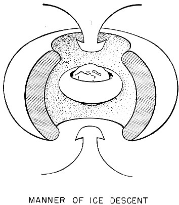
The second phase of transport in the uniformitarian theory implies that most of the snow fell in the regions of the nodes, where ice piled up to an altitude of 3 miles. However, these nodes were great distances from the oceans, and warm, humid air would normally drop its moisture on the fringe areas of a cold region rather than at the heart. Thus it is seen that on any one of these transporting viewpoints, uniformitarian theory extensively and consistently fails. According to the catastrophic theory, the ice was transported across the solar system in an eccentric or comet-like orbit. It was transported from its previous orbital location or galactic region in this first phase to the Earth-Moon region. The second phase was a deflection of the cold ice particles within the Earth-Moon system by the radiation belts (Van Alien belts) of the Earth. It is thought that the particles of ice, being electrically charged, were deflected, or shunted, or redirected by the magnetic field, as are charged particles during periods of sunspot activity. The particles apparently converged over the magnetic polar regions, and in converging they bumped, experiencing intra collisions, which reduced their velocity, causing them to decelerate, and proceeded to descend. They descended over a vast magnetic polar area and concentrated in different but proximate locations or nodes during the various descents. Thus were formed the epicenters or the nodes of the ice mass. The super-cooled ice particles descended mostly in the higher latitudes because the Magnetic North Pole happens to be located only about 1200 miles from the Geographical Pole--the Earth's axis. Had the magnetic pole been located in another latitude, the Ice Epoch activity would also have been in another latitude. |
|
|
|
Every evidence suggests that the descent of ice occurred suddenly,
in great volumes, at extremely low temperatures, and over a vast area proximate
to the magnetic poles. During these periods of ice descent, ice may have
cascaded or descended at a rate of several hundreds of feet per hour, in
the regions of the epicenters. There may have been five or six separate
crescendos of ice influx spread out periodically across the first several
weeks of this cataclysmic Earth crisis. The fact that ice did happen to
fall mostly in higher latitudes is indicative that there is a relationship
between the magnetic axis and the geographical axis.
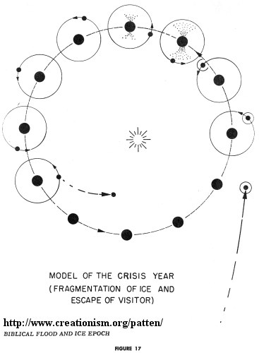
It is also true that on the fringes of the ice mass, ice was concentrated in mountainous regions. This is substantially associated with true climatic but post-diluvian developments during a period when ice was melting, oceans were filling up with cold water, the climate of the Earth was temporarily chilled, and much snow fell as part of the aftermath of this icy crisis. With regard to manner of transport, the first stage involved an elliptical orbit, and also involved hundreds of millions of miles of inter-planetary distance. The second stage commenced within the Earth-Moon system, and it involved tens of thousands of miles of distance and magnetic redirection. On the basis of horizontal transportation of ice across the solar system, it is recalled that clues to the cause of the Earth's Ice Epoch are similar to clues of the cause of Saturn's icy rings. And also the composition of captured material in our Ice Epoch is similar to the composition of such icy satellites as Callisto, Ganymede, Iapetus, Titan and Triton. Chapter VII contains a model of the astral catastrophe. It includes 8 line diagrams and 40 listed categories of assumptions and conclusions, describing the catastrophe. It is thought that the duration of the chaotic conflict was five or six months, and the visitor was finally disengaged from the Earth-Moon system only after the Earth passed from aphelion toward perihelion, and only after at least two close approaches had wrought their havoc on our planet. Further particulars are contained in Chapter VII. |
It should also be noted that the Moon today has an orbit with an eccentricity
of .055, whereas the Earth has an eccentricity of only .017. Is it possible
that this astral conflict partly explains the Moon's greater eccentricity?
The Location of the Deposition of the Ice. Two areas of basic consideration have been discussed: (1) the area of the origin of the ice and (2) the mode of transport of the ice. This third area, the location of the deposition of the ice, is related to magnetic latitudes rather than to geographic latitudes, it being essentially a magnetic phenomenon. This is the basis for the eccentricity of the Ice Epoch area to the North Pole.
| The location of the deposition of the ice is completely related to
the remote astral origin and the manner of transport. It is also completely
related to such factors as the geometry (conical shape) of the ice mass.
It is similarly related to such factors as subsequent outflow, heat exchanges,
heat equilibriums, subsequent melting, unearthly extremes in temperature
of the ice, and in its sudden appearance.
Catastrophic theory can explain all of these phenomena. It can explain the presence of ice both upon continental massifs and on sub-oceanic bedrock; it also explains the simultaneous gravitational upheaval (and lava outflow) which mixed descending ice (in the peripheral regions) with upwelling magma or descending pumice. Thus is explained the ice sandwiched even to this day between inordinately cold layers of lava. The uniformitarian approach can explain none of these adequately. It invokes climatic mechanisms to freeze mammoths by the millions. It invokes heating mechanisms (evaporation) to explain cooling requirements, and it invokes moderating mechanisms (wind systems) to explain temperatures of unearthly extremes. It has no mechanism which can account for a very minor fraction of the septillions of calories of heat loss which are involved, to say nothing of the required suddenness. Uniformitarian theory is hard pressed to adequately handle as much as one of these phenomena, much less the whole panorama in tandem. Uniformitarianism may be a magnificently successful misinterpretation of Earth history, and even in its academic success, it is hardly to be admired. But in all justice, uniformitarianism must be admired for one thing--consistency--for its errors are markedly consistent. |
|
The Dating of the Ice Epoch. The dating of the Ice Epoch is essential for the proper reconstruction of ancient history, regarding both the Earth and its biological population. Prevailing opinion has placed the end of the Ice Epoch between 8,000 B.C. and 11,000 B.C., which is a substantial adjustment from Lyell's adjusted 40,000 B.C. or his original 1,000,000 B.C. (a date still used to explain the lava upwellings of Eastern Washington). It is obvious that recent investigations have tended repeatedly to update the Ice Epoch to a more recent time.
The dating of the Flood-Ice catastrophe, as conceived by the author, is about 2800 B.C., plus or minus 500 years. The case for the recent dating of this catastrophe is far from complete at this point; actually it has only commenced. This catastrophe included such geophysical developments as the uplifting of the Alpine-Himalayan and Circum-Pacific orogenetic zones, simultaneous with the uplifting of the Earth's oceans and the descent of the astral ice.
Among the categories of evidences to be considered is the Biblical chronology, painstaking logged, carefully preserved, and probably accurate to a high degree. Along with the Biblical account, ancient folklores and mythologies from several other continents agree with the principles and themes, contained or implicit within the Biblical account.
A second category of evidences, to which Chapter VIII is addressed, is the recent dating of subsequent celestial catastrophes, well-recorded and clearly dated within the 2nd and 1st millenia B.C. This will lead to the conclusion that disorganizations within our solar system have been recent, and it also means that the Earth has been among those bodies involved. This does much to discourage an extended or distant dating of the Flood catastrophe.
A third category of evidences is related to changes in the Earth's atmosphere from the Antediluvian to the Postdiluvian Age, and the "greenhouse effect" which dissolved at that time. The Greenhouse Effect is related to chronologies, longevities, climates, and biochemical curves, which furnish further substantiation. A discussion of this subject is reserved for Chapter IX. In total, these categories of evidences will merge into a strong web of logic encouraging a recent dating for the Flood.
And if the recent dating of the Flood is simultaneous with these glaciogenetic and orogenetic principles, as is herein affirmed, then the conclusion inevitably follows that the uniformitarian principle of dating has been conceived either immaturely or prematurely, or both.
Problems concerning prime theory of glaciogenesis and orogenesis have been mistakenly assigned to the geologist. They more properly should be assigned to the astronomer or catastrophist possessing the historical perspective of catastrophism. Once this is done, and the astronomer establishes prime theory, and the geophysicist establishes secondary theory, then the geologist is to be accountable for filling in the details of local deformation, local fossilization, and so forth.
Again, it must be emphasized that not only have geologists failed to
establish secondary or local theory for Earth structures; astrophysicists
and geophysicists (educated to uniformitarianism only) have also failed
to establish prime theory for Earth history. It is with this in mind that
Chapter VII is presented. It contains a series of definitive assumptions
and conclusions, and accompanying line diagrams, which describe this event.
These line diagrams comprise the model (as the author best conceives) of
this, the greatest celestial crisis which our planet has thus far experienced.
"The Biblical Flood and the Ice Epoch" by Donald W. Patten - is ©1966 by Pacific Meridian Pub. Co.
| << PREV |
|
|