Noah's Vessel: 24,000 Deadweight Tons
<http://www.creationism.org/patten/WindsorNoahsVesselInTons.html>
|
|
|
NOAH'S VESSEL: 24,000 DEADWEIGHT TONS
Copyright © 1995 - By Samuel R. Windsor
THE FASOLD FORMATION COMPARED TO TRADITION
SIGNIFICANCE, CONCLUSIONS AND QUESTIONS
IF WISHES WERE HORSES (BEGGARS WOULD RIDE)
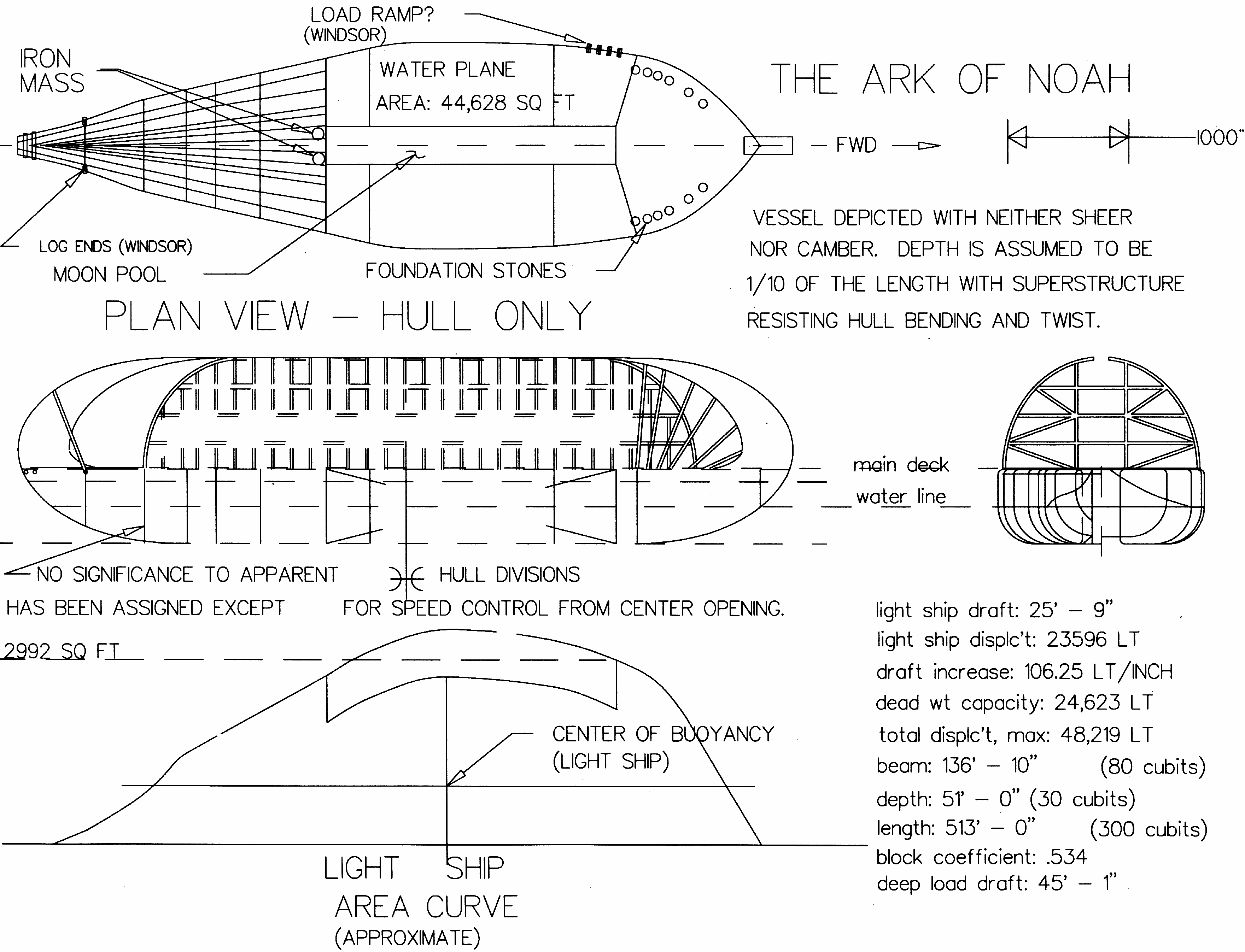
Figure 1 Plan View - Hull Only
Figure 2 Plan View - House Top
Throughout the last 4 1/2 millennia, much has been written about Noah's Ark (Genesis), Nuh'un Gemisi (Turkish), the vessel of Utnapishtim (Assurbanipal's Epic of Gilgamesh), the vessel of Nu (Egyptian legend), the vessel built by Manu (Vedas of India), etc. Most books attempt to authenticate the various stories by comparison, religious faith, etc.
No one has seriously evaluated Noah's Ark as a sea going barge. Such an examination is possible using the artifact measured dimensions published in "The Ark of Noah", by David Fasold, Wynwood Press, New York, N.Y., 1988. We are limited to the plan view only. We lack depth dimensions until more sophisticated non-destructive measurements are taken of the Ark formation.
I assumed David's measurements are accurate. Some were corroborated by myself in June of 1990. Depth assumptions are based upon an ancient hull form used by Thor Heyerdahl for his construction of the "Ra I", "Ra II" and a few vestiges of Egyptian hull forms used later in wooden vessels.
I also assume that currently accepted principles of marine engineering are applicable to the vessel's environment, i.e., sea water weighed 64 lbs. per cubic foot, etc.
DEADWEIGHT refers to the carrying capacity of a vessel in weight, not volume. DISPLACEMENT refers to the total weight of water displaced by a vessel. Thus, displacement at full load is the total of the deadweight and the empty vessel displacement, SUPERSTRUCTURE consists of the house, masts, etc. built above the main deck of a vessel.
SCANTLINGS refer to the skeletal structure of any part of a vessel. CENTER OF BUOYANCY is the exact center of the "hole in the water" made by a vessel. CENTER OF GRAVITY is the exact center of all of the "weight" of a vessel and its cargo. (These two centers are always in vertical alignment when a vessel is at rest in the water.)
STERN is the back; BOW is the front; PORT is the side on your left when you face forward; STARBOARD is the side on your right when facing forward. MAIN DECK is the top surface of the hull in our case and HULL is the board part of the vessel, as opposed to the superstructure or "house part". A MOON POOL is a vertical hole clear through the vessel (rectangular in the Ark), from the main deck down through the bottom (most commonly found in modern drill rigs). DRAFT is the hull depth below water line. FREEBOARD is the distance between deck and water line. METACENTER is an imaginary point in space, above the center of gravity. It can thought of as a point from which the vessel would swing, were it a pendulum having the same swing period as the vessel has roll period. The distance between metacenter and center of gravity is call GM. This is the dimensional measure of STABILITY or the reliability of the vessel remaining upright.
Both David Fasold and John Baumgardner independently measured the Ark Formation's "shape" in plan view. They both used subsurface metal detectors and frequency generators with identical results. A more complete description of their conclusions can be found in Fasold's book, including commentary on finding nearly 5400 ferromagnetic (iron) readings, in patterned location, throughout the Ark formation.
The largest wooden vessel ever built by modern man was under 350 feet (in the nineteenth century). It was the U.S.S. Wyoming and was a structural failure. Our overall conclusion is inescapable that the Fasold artifact is the remains of a reed raft with some sort of bulkheading or transverse bracing and binding.
Figure 1 is produced from Fasold's dimensions and sketches. The "Plan View" is a scale drawing of the measurements taken and shown in his work, "The Ark of Noah". The balance of Figure 1 as well as the drawings and calculations in Figure 2 are produced from some elementary assumptions concerning form, floatation and sea keeping requirements. The capacity characteristics, stability, etc. shown in Figures 1 and 2 are simply calculated results using Fasold's dimensions and the assumed depth and midship section. (There is no intent to say the vessel was actually laden with 24,000 long tons of cargo and crew.)
I calculated the length of the cubit by dividing 300 into the Ark's measured length, 515.7 feet. The 137.5 foot beam (width) of the vessel then becomes 80 cubits. Because of the builders' apparent fascination with the number phi, 1.62, the depth is taken as the beam divided by the square of phi or 80/(1.62 x 1.62). Phi is called the golden ratio. It is the number obtained by dividing any straight line into two segments, a and b in length where b/a = (a+b)/b.
Genesis gives the volume of the Ark as 300 by 50 by 30 cubits. Ancient writers did not always use an expression for cubic measurement and appear to have given its volume in terms of the product of three numbers. They either had no way of saying 450,000 cubic cubits, or didn't choose to do so. (I understand this is still a practice in some languages, today.) Logically, any one or two of the three might be a specific dimension; or perhaps none are. I've assumed the 300 cubits to have been a real dimension because the length of 20.625" is within the range of the "cubit" as discussed by scholars over the years.
In any case, a vessel with a length 6 times its width and 10 times it depth, as the translation has it, is appropriate only for modern steel barges; and then only when the cargo is carried below the main deck.
The box-like artistic depiction of the Ark over the centuries has implied the hold was water tight with the cargo stowed below water line. This line of supposition ignores the need for bilge pumps and piping. Further, it is impossible to build a seaworthy, large, slender, thin shelled vessel out of wood. Such configuration requires steel plate and scantlings.
Traditional artists' paintings ignore the need for a protected work area on the main deck. Such an area is needed for line handling during docking and maneuvering. The Ark had to be handled afloat at the terminus of its trip. Were it allowed to ground before unloading, it might have followed the draining water rushing back to the Caspian sea. If the Ark couldn't be unloaded while afloat, the unloading process might well be a sudden, capsizing motion as the vessel grounded on a slope it couldn't accommodate. The master (Noah) would have been concerned about ship wreck! He had to solve some world class maneuvering problems to safely deliver his cargo. He had to successfully locate a beach, maneuver the vessel to it, and moor the vessel to prevent drift. To get his cargo off safely was sufficient miracle to warrant thanksgiving. These aspects of Noah's experience are passed over as unimportant by artists and authors having little marine experience.
Fasold discovered that the vessel was a shaped, reed raft with a multiple deck superstructure providing rigidity. This boat shape makes plausible both the great size and the general mission of the vessel. ("Raft" comes from the Latin "ratis" or vessel without a keel.) My assumption of bilge radius equaling 25'-9" and of stem and stern profile radii approximating 65', is conservative. The actual bilge radius may well have been sharper (less) or the stem and stern profile radii greater (or non-circular). These dimensions also roughly reflect the form later Egyptian boat builders employed. They are similar to the form used by reed raft builders in both South America and North Africa.
Although a sharper bilge radius (more rectangular cross section) would increase dead weight by adding volume to the hull, the price paid would be a jerky ride. This discomfort in severe weather isn't worth the gain in cargo capacity, so I made no attempt to persuade myself or my reader that we should leave tradition and assume unusually sharp bilge radii. Moreover, the presence, size and location of the moon pool indicates EXTREMELY SOPHISTICATED VESSEL DESIGN. The snappy roll of a too full (rectangular) hull form would impose tortuous forces on the structure, the cargo and the passengers. This simply isn't in keeping with the otherwise clever design of the artifact.
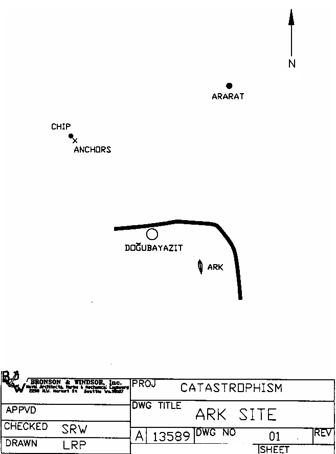
Fasold assumed the raft profile of the Ark was the same at both ends. However, he found large "foundation" stones along the gunnel only at the bow. My own examination of the Ark site in June 1990 supports a configuration that curls the bow stem back and over the fore deck but blunts the stern at a stern log. I have shown this slight modification in the drawings.
The moon pool appears to have transverse bulkheads at both ends. The aft bulkhead of the moon poo1 seems to be triple. Fasold's metal detector results show three rows on iron "fittings" about 30" apart. This bulkhead appears to be snagged on the large rock. The rock prevents the artifact from sliding downhill with the mud flows that surround it. The moon pool is located 55' (exactly 32 of our cubits) aft of amidships. This is an extremely significant position and later in this paper, I will discuss it more.
Fossilized log ends appear several places along the gunnels and at the stern. These logs show complete circular sediment layering and they are uniformly round. They also appear only outboard of the gunnel center line, with two exceptions. I believe the two inboard exceptions result from the absence of the superstructure in this area when the vessel became covered with mud. The mud covering the exterior of the Ark found its way inside the hollowed out hull here. Mud imbedment of the log ends permitted their replacement by silt during the rotting process. This area is about 45 yards from the stem, on the port side. This suggests the unloading access hole in the superstructure was not closed after its last use. The lack of inboard log projections elsewhere, either means that there were none or that soil was excluded in the structure during the wood rotting period and these logs had to rot in an air environment.
The Ark's remains appear to have rotated counter-clockwise, crushing the port side on a large, snagging rock, and come to rest on it. The soil around continues to flow downhill (at 11 degrees) while the formation only pivots slightly about the rock. The total swing of the artifact from the vessel's original beaching position appears to have been at least 240 degrees. This observation follows from thinking the loading ramp was on the port side, forward. The original beach is two hundred feet higher, and is southwest of the present site.
For the reader interested in examining my value assumptions, they are:
THE FASOLD FORMATION COMPARED TO TRADITION
The reader might not be familiar with all of the reasons modern vessels are shaped and equipped as they are. Some of the reasons are found in the limitations of the materials used.
A floating vessel is like a long beam in that it must resist imposed forces while supporting its own weight and that of its cargo. A vessel is subject to bending, both up and down and sideways. It is also subject to twisting (torsion) of one end relative to the other. When a vessel is riding on a single wave amidships, its ends will be over the wave. Such bending is "hogging". When the vessel spans two waves, it bends downward into the trough. This is "sagging". When the bow takes an off center wave to the port bow while the stern is still riding an off center wave to starboard, the ship will twist. This is "wracking". Waves rising suddenly under bow or stern produce "slamming". A vessel pivoting in the plan view about a vertical axis through its center is "yawing". A vessel pivoting about an axis fore and aft is "roIling". "Pitching" occurs when a vessel pivots about a horizontal, transverse axis.
The weight of the vessel and cargo provides "inertia" and some time increment is required to move it, change its direction or change its speed of motion. The time increment is influenced by the shape of the vessel. If the surfaces are square cornered and flat, the time increments during wave application are so short as to be impact or shock. If the shapes are soft and rounded, the time increment extends so that the motion is changed with less force. One consequence will be a more comfortable ride. The important consequence will be survival of the structure . A smooth ride is required if the crew must feed and maintain animals. Neither the animal nor the handler's digestion is improved if the crew must hang on for dear life in virtually all sea states.
The shape of the vessel is also dictated by its mission. A river raft travels among established dock facilities in protected water. It needs less freeboard than does a sea going vessel. It need not be arranged to facilitate 30 to 60 degree rolls and 15 degree pitches. The sea going vessel must remain upright in sea states never experienced by the river raft. A measure of this stability is the "GM".
Recall that GM is the distance between the center of gravity of the loaded vessel and an imaginary point called the metacenter. The metacenter can be thought of as the point in space from which the ship would swing were it a pendulum having a swing period equal to the actual roll period (or pitch period).F3
For a piece of pipe or round log this point- is in the center and coincides with the center of gravity. This explains why a pipe or log rolls so easily, it "spins" in the water. As the shape assumes more elliptical configuration, this point rises above the center of gravity. Here, it provides a definite preference for floating with the flatter side down and the sharper radiused sides port and starboard.
As the hull shape becomes more rectangular, the metacenter rises so high that even small rolls result in tremendous force righting the vessel. This makes the vessel snappy and imposes the forces that throw dishes off of counters, that pop pump foundations loose, and result in a poor ride and failed structure. Attempts to preserve a stable condition in an active sea, while softening the impact of wave action, account for the considerable variety of modern vessel configurations. The ideal shape differs for each cargo, each environment (wind, wave height expectation, temperature, etc.) and each power source. Artistic representations of Noah's Ark and insistence that it had to be a box 300 by 50 by 30 cubits contribute to the fact that few scientists and no marine engineers (to my knowledge) have previously expressed interest in pursuing any analysis of the Ark, Noah's voyage, or any part of that fuzzy sector of history.
A reed raft in the shape of the artifact southeast of Dogubayazit, Turkey, is four times more stable than is the traditional 50 cubit beam. The stability varies with the cube of the beam (80 x 80 x 80)/(50 x 50 x 50) = 4. More significantly, the traditional 50 cubit beam with 30 cubit depth is too slender to permit a superstructure. Yet, the length of the vessel at 300 cubits is so great that the additional depth contribution from a superstructure is required for all materials except steel.
A reed raft in the tear drop shape of the Fasold formation can be handled and maneuvered in adverse currents by skilled dragging of anchors in combination with selecting the wind presentation. This is the reason the ability to pivot the vessel about an anchor line is so important. Without sails, the superstructure can be used as a sail, provided the anchors can be played like the doors of a trawl net and provided the hull form is "racy" with an underwater shape that won't result in the vessel crabbing sideways in high velocity water flow. The fine stern (long, narrow "back end") of the vessel will act like the skegs of a modern barge (and like feathers on an arrow) and will assist in maintaining the bow forward when wind force exceeds water resistance. However, the traditional "box" will rotate to about 9-1/2 degrees sideways, heel over in an angular wind, roll violently, and possibly capsize. It virtually cannot be handled.
The majority of the anchor stones are found near the village of Kazan, a few miles northwest of Dogubayazit. One anchor stone is in Ankara. This stone in Ankara is traditionally thought to have been imported from Egypt. More probably, it was used on the original Ark and was later imported from Eastern Anatolia.
The flailing anchor we looked at in Kazan differs from the other stones in that the hole is located about 1/3 down from the top. It is shaped like one wing of a butterfly. It is used by banding the line around the stone, full girth. The tail is tied through the hole to prevent slipping and brought around and tied off to the drag line. This forms a bridle. If the stone lies such that the bridle part to the hole side is shorter than the drag line part, the stone will drift to one side when the wind blows the vessel.
The vessel is then drifted downwind while paying out the flailing anchor until it hits bottom. A heavy anchor is dropped straight down after the vessel comes down wind of the grounded flailing anchor. The flailing anchor line is hauled in, and the anchor is retrieved. The heavy anchor is weighed or cast off and the process repeated. This will bring the flailing anchor again to an angle behind the vessel. Lifting or cutting loose the heavier anchor line lets the vessel swing on the flailing anchor line, downwind. This is the means by which the vessel may be worked crosswind.
The village of Kazan lies just north of an enormous upthrust of rock that appears to have been a temporary shelter for an anchored raft. The rock "island" would have permitted tying up while waiting for a landing beach to appear. Further, it would have provided sea water level perception to a master in waters that were totally unfamiliar.
When Noah observed that the mountains appeared after several months, he probably was saying that they had been obscured by fog, clouds, and volcanic dust in the air. (The enormous body of water was still warm from residual heat before the flood. This water would be covered day and night with heavy fog due to cold air above it. The cold air also would be full of volcanic dust resulting from the volcanic activity prevalent on a hemisphere wide basis, including Mount Ararat and Little Ararat.) This late appearance of the mountains is traditionally assigned to mean that the mountains emerged from the water.
However, such a meaning isn't required by the literature. It is presumed only by those failing to note the catastrophic effect on the Earth's crust of the total flood event including the fact that residual heat in the flood waters had to be given up to cooler air above them.
Two miles to the west of Kazan lies a chip of rock that appears to be made of evenly laminated material and is ridged in 1-1/2" concave troughs on both large surfaces. The troughs appear in the pattern of bundled reeds, but have been weathered severely. The chip is about 16" thick, four feet wide and eight feet long. If it is from the deck covering of the reed raft, the Ark, it was broken loose about the time the vessel began its final voyage to the beach site several miles to the east. Material such as this was smeared on the Ark deck for water runoff and to protect the reed mat from animal urine. A reed mat that might well have been in the first stages of disintegration. This would help motivate Noah to find a berth soon, using the winds and anchors to navigate. (I think it likely that the outflow rate was increasing so rapidly that he didn't need other "motivation".)
The lie of the land, location of the Ark site and the anchor stones suggest that Noah had a few, really bad moments between his last anchor site at Kazan and when he beached the vessel. Some of the choices may not have been his. The Ark site is located in the last protected "cul de sac" in Turkey before the outlet to the next lower valley eastward into present day Iran. (See figure 4, the Ark Site Sketch.) Noah elected to cast off from his protected anchor site when a major water dam broke 150 miles to his east. He then had no choice but to go with the flow. He had to use the first beach he found, ideal or not. Noah's problem was to find one and tie up to it before the outflowing water became a torrent, impossible to navigate.
This is the stuff for an adventure movie. A strong water current draining the lake and the accompanying severe wind may be why Noah elected to weigh anchor! His depth soundings would have informed him at his anchor site that the lake bed was level. Had he been lucky, the outflow would have been gradual enough to allow him to ground the Ark "straight down" (in the manner assumed by most non-marine students). However, his beaching at the last possible site before a down hill run suggests much anxiety aboard the Ark in the last few miles of her voyage.
He made the turn into the cul de sac with very little margin for error. That he was saved from rocketing down into the next lower valley, probably is a miracle on par with the one that sustained him while being swept inland and upward by tidal forces in the first place. The record states that a "great wind" passed over the Earth and the waters receded, in this case downward into the Caspian Sea. The usual reading of this text confuses cause and effect. A violent river breach occurred to the east through a ridge of mountains that formed a dam. The trapped, inland sea, began to empty. It Would contribute to an accompanying "great wind" from the northwest.
The boat shaped formation I examined and Fasold measured appears to have had sea keeping features appropriate to both its mission and to materials in use for vessels at the time in which it was built. These are not the result of a "natural formation". There is an old "saw" in the field of statistical probability suggesting that if components of a modern battleship were all thrown into a large, erratically sloshing tub of sea water, there is a minute probability that they would assemble themselves into a working weapon of war. That probability, however, is "very low" and is never seriously considered when a battleship is cited! Similarly, consider the probability that nature might provide a "dirt, iron and rock" formation with all of the following properties:
SIGNIFICANCE, CONCLUSIONS AND QUESTIONS
I find these data very convincing that this isn't a natural formation. I further, have seen nothing convincing me this formation was a land side building. Nor do I have any reason to think a later vessel was built on site to sail in some prehistoric lake. The reasonable question isn't "is this all that remains of a vessel?" The reasonable questions are:
Was this the vessel built by Noah, and if not, who did build it?
Was this vessel built locally, at 6300 feet elevation, at time when this area was a mighty lake? There is absolutely no evidence for such a supposition.
Where did the iron come from if the Hittites were the inventors of the iron smelter? (The Hittites, who lived here at a later date, might well have found the iron from the Ark. Using the coal available in the mountains around, they learned how to smelt the iron. The iron dagger in Ataturk Museum supports iron smelting pre-dating the Hittites.) If the presence of iron in the formation is just coincidentally in the land inhabited by them, wouldn't a skeptic be justified in questioning such "chance"? Other cultures were more advanced in all of the required resources, except one. The others didn't have an artifact with old iron fittings in it, that illustrated to them both material and application.
Where were these anchor stones quarried? Does the quarry still exist (or has it been submerged ever since)? What celestial forces were operating, creating tides on the Indian Ocean that were powerful enough to wash the Ark inland and upward?
The mountains had to have been upthrust even while the water brought the Ark inland, and upland so as to trap the vessel. This offers an explanation of why her master was forced to wait until valley outflow exposed some beach. Were the mountains lifted into place by the same extra-terrestrial force (a flyby planet) that washed the vessel inland? Continents may drift, but is their drifting responsible for the formation of mountain ranges? (Suggested reading on this subject are several of the writings by Donald Wesley Patten).F4
Is it a coincidence that Mt. Ararat belongs to the same lineal pattern as the highest mountains on Earth, the Himalayas? Does this not suggest that the enormous flood depositing the Ark in Eastern Anatolia (Turkey) resulted from the same extreme celestial event that formed those mountains? (See Patten and Windsor's, "A Catastrophic Theory for Mountain Uplifts".)
Because the Ark was constructed with such a single special purpose in mind, was the flood event predictable? The Epic of Gilgamesh says it happened "when the fixed time arrived". Our several major religions claim its coming to have been the subject of divine communication with Noah. However, engineering concepts must relate to the existence of the artifact along lines of mechanism because it is a real object and its presence must be explained in engineering terminology.
Assuming predictability, was the flood simply a worst case version of a previous catastrophic occurrence? The records indicate that less severe, yet major catastrophes occurred on anniversary dates. (This periodicity included several "Passovers".)
Was this repetition periodic because its cause relates to planetary motion and regular orbit? Can that account for the ancients' preoccupation with the doings of the various planets? We could certainly never convince all peoples on Earth, today, to fear "the stars
Does such repeated flooding experiences account for the strata we find on all continents, little of which is found in the ocean floors?
Does such repeated flooding experiences account for the ancients' preoccupation with building things out of massively large stones and arranging them so that except for Britain's henges, they won't topple in high velocity currents?
Can this particular flood explain the formation of crustacean borings on the sides of the great pyramid in Giza.
Can the extreme cold Noah experienced the year after the flood relate to extra-terrestrial sourced ices and gases streaming in at the magnetic poles and freezing giant mammoths from the inside out, in their tracks, as they munched happily on their buttercups near what is now the North Pole?
Does the presence of this one nautical artifact bear witness to the accuracy of ancient literature describing the periodic orbital interference with Earth by the planet Mars? Mars' orbital interference with Earth is a possibility raised for Earth by Gerald Sussman some 300,000,000 years into the future.F5 Sussman hasn't addressed ancient descriptions of the orbital interference he postulates for the future. His interference's have already been experienced and described, if one is to take the ancient literature seriously. An example on nearly everyone's book shelf is the change of Earth's axis tilt to the solar plane noted by Isaiah; 38:8.F6 These same scriptures connect electrical effects to the disastrous end of Assyrian military aspirations by fire from heaven. (A similar fate was experienced by the Greeks at Troy, earlier.)
If one doesn't take the literature seriously, we have no rational explanation for the pre-telescope knowledge of Mars' two satellites ("Gulliver's Travels" by Jonathan Swift and Hesiod's, "The Shield of Herakles"). Neither can we explain why ancient people couldn't count, judging from the fact that all calendars before 701 B.C.E. employed a 360 day year (Rome's 10, 36 day months, the Mayan 72, 5 day weeks, the Chinese 24, 15 day periods, Judah's 12, 30 day months, the 360 degree circle ... etc.)F7
IF WISHES WERE HORSES (BEGGARS WOULD RIDE)
One would hope that the Turkish government finds the funds and interest to move the "chip" and anchor stones either to a museum or to the Ark site where they can be protected. The local people use the anchor stones for walls of small buildings (such as an outhouse) at the present. Protection of the exposed Ark artifact may be a futile hope, technologically. However, the Turkish government has built an observation building above the site to encourage viewing before the formation further disintegrates.
I would also encourage a project of flying over the site by helicopter with infrared photography. Pictures should be taken in three passes per hour during the night between the end of one hot day and the beginning of the next. One pass of each set should be directly above the center line, fore and aft and the other two down each side, with the camera at an angle to the formation. The differing heat capacities of the material in the artifact might then portray its skeletal structure.
The light (and "heat") such scientific investigation would produce might illuminate subjects like the source of Earth's geo-magnetism, and the reason for the rapid decay of the geo-magnetic field. It might allow discovery of the reason for the cooling of the Earth and an explanation for the lack of ancient storm activity. Reports of oxygen ratios as high as 36% in ancient atmospheres (found in amber) and lush forestation in "pre-historic" times preclude lightning as we know it today. Such an atmosphere would never have rain, but would instead condense moisture out of air at night; pretty much as is described in the ancient records for the antediluvian environment, an ancient greenhouse atmosphere.
The reason the ancient people were convinced that the Earth rode on the head of a bull and that earthquakes resulted from his shaking his head is an equal mystery. Perhaps they viewed Mars with electron flux tubes curving up to Earth's magnetic north pole and down to Earth's magnetic south pole ala' Io/Jupiter. (One half of this circuit would appear to be the "Sword of the Lord", or the "Scimitar of Apollo Shootafar".)
Perhaps the reason for most modern earthquake activity can be learned. Is it that the continents are still reverberating and adjusting from planet wars with Mars? The system, fortunately came unglued around 701 B.C.E.
Were the astrological signs named 60 degrees ahead and over 4000 years before the constellations defining them arrived at the points where they correctly relate to Earth's spring equinox? Could orbital precession have reversed periodically so that there was no net change in the fixed stars' positions for over 4000 years?
Such informational light might be quite blinding! It might even result in the correction of the "dating" systems that produce such bizarre conclusions as 70 million year old Etruscan sandal prints, fossilized woven cloth in Precambrian granite and 18' tall animals freezing from falling into water that became ice. Such freezing requires a freeze rate of temperatures below -300 degrees Fahrenheit! It takes -40 degrees F to freeze a 4" thick salmon fast enough to prevent deterioration of the "gut". Scientists and Eskimos have dined in our generation on mammoth meat quick frozen millennia ago in the Arctic. These animals were feet not inches thick.
The lack of public interest in the Ark site may not be "all bad". Religious "Ark hunters" have used dynamite trying to find 5000 year old wood! Exploration of the site should be by helicopter or airplane, using sophisticated, non-destructive examination methods. This author hopes that electronic exploration can be just as satisfying as climbing around on the Ark formation. It still would provide an enjoyable trip to a beautiful country and it would open to pilgrims the reality of our heritage.
Various organizations and foundations have an apparent interest in "the Ark of Noah". However, they have an established opinion concerning the vessel or its location that is too inflexible (must be on Mt. Ararat) to allow consideration of actual evidence when that evidence suggests error in their pre-suppositions. Even finding the ship's builder's plaque in pre-Chaldean script wouldn't be convincing to such investigators. The possible salvation of the Ark formation and the anchor stones falls to those who are not locked into any of the various dogmas that substitute faith and guru worship for evidentiary truth and logic.
Recent studies of the planet Mercury proves the bankrupt nature of the geo-dynamo theory. (Mercury has a solid core, not a liquid one.) The Sun is the generator of Mercury's electro-magnetic field. Jupiter's satellites, including Io are the generator of Jupiter's field, Triton of Neptune's and Uranus' satellites of at least half of Uranus' field (the remainder being residual). Mars is the author of 97% of Earth's residual field. (And, we are losing it. Earth's field strength is declining by 4-1/2% per century.)
Sussman's studies in chaos mathematics applied to the inner four planetary orbits shows them to be unstable. One of the "strange attractor" or probable. configurations is an elongated Mars' orbit and/or an elongated orbit for one of the asteroids. NASA's Magellan is sending us pictures of sharp features, mountains and canyons on Venus that should have been worn away ``millions'' of years ago under the Venusian heavy, corrosive, eroding atmosphere. Surely, this would be the case were it not for Mars' ancient 66,000,000 mile perihelion being so "recent". Mars ancient orbit brought it inside Venus' orbit and caused some of the same features on Venus as on Earth. It was probably Venus that influenced the break up of the resonant system in 701 B.C.E., resulting in the rounding out of the orbit of Mars.
Detractors can sputter and protest but the cat is out of the bag. Pandora's box is opening and the escaping spirits taking flight this time are shafts of truth. Truths are emerging, long suppressed on the altar of self aggrandizement and emotional need for scholarly conformity.
David Fasold espouses the correct Ark site. His conclusions are founded on evidence and logic. His detractors support their opinion by "other opinion" and lack the support of either evidence or logic. Donald Wesley Patten has the correct mechanism for flooding the Earth and raising mountains. His detractors are very selective in their considered evidence. Patten's detractors favor a bankrupt cosmology that is demonstrably wrong. The several versions of the Nebular Hypothesis are, after all, absolutely without supporting evidence. Any theory espousing the formation of the several planets where we find them today, has one primary obstacle to acceptance. It must reject actual evidence and fundamental engineering principle. A second, lesser millstone is that such a theory must coexist with written record in literature identifying the theory as hogwash.
This author is having a great time watching a naked establishment marching off into a sea of absurdity. Their bankrupt uniformitarian conviction is being pummeled by every revelation of the NASA probes, by the polar explorations celestial geographer, Donald Wesley Patten, and by one Mr. David Fasold, ship salver.
F2 Drilled, curved holes in stone also are found in the plumbing systems in South and Central American structures. There they drilled curved holes in large stones, and then fit the stones together so perfectly that leakage was insignificant. To my knowledge, we have no idea how the ancients drilled such curved holes. The uplifting of mountains after stone edifices were built in the Andes is the logical explanation for how 1000 ton stones were moved among, what are today, mountain tops. The Earth existed before its inclusion in our Solar system. This is the logical explanation for how Earth captured a Moon that cannot be captured in Earth's present Solar orbit. We know Moon and Earth didn't form simultaneously, as planet and satellite, because the Moon is made of different stuff than is Earth. The "mountains of Urartu" were raised up by the same tidal forces imposed by Mars that trapped a raft at 6700 feet elevation. This is the only rational explanation for finding the remains of a vessel southeast of Dogubayazit, Turkey today. (It is now at 6300 feet.) Our halls of learning seem to have equal difficulty with all such rather obvious observations. The problem isn't the logic involved. The problem is that the conclusion violates prejudiced opinion. Learned response to such violation is nearly always a proclamation that the evidence does not exist. For some obscure reason, this response seems to be effective among the credentialed members of the establishment while singularly ineffective among "laity".
F3 Practically, the metacenter can be approximated graphically as follows: (See Figure 3.)
F5 "Gravity's Revenge" by David H. Freedman, Discover Magazine, May 1990
F6 "Watch the shadow cast by the Sun on the stairway of Ahaz: I will bring backwards ten steps the shadow which has gone down on the stairway down which it had gone:" Isaiah 38:8 This verse identifies not only that the latitude of Jerusalem changed while Hezekiah and Isaiah watched; it also had changed earlier within the memory of their culture! This speaks strongly of the periodic nature of the celestial goings-on that is found so prevalent throughout the Bible, Homer's Iliad, Gilgamesh's Epic voyage, etc. If our predecessors thought their descendants would live in such a celestially peaceful state that their catastrophic histories wouldn't be believed, they might have left even better records.
F7 "Response to Critique by Leroy Ellenberger" by Donald Wesley Patten, Page 77, C & AH Volume XII, Part 1, January 1990.
Figure
1
Plan View - Hull Only
Figure
2
Plan View - House Top
Noah's Vessel: 24,000 Deadweight Tons
<http://www.creationism.org/patten/WindsorNoahsVesselInTons.html>
|
|
|