|
|
|
|
|
|
|
|
|
|
|
|
|

The article below (from "A Symposium on Creation" Vols. 1-5 @ http://www.creationism.org/english/symposium/) is used by permission of Baker Books, a division of Baker Book House Company, copyright ©1968-1975. All rights to these materials are reserved. Materials are not be be distributed to other web locations for retrieval, published in other media, or mirrored at other sites without written permission from Baker Book House Company.
Stratigraphic Evidence of
the Flood
by Stuart E. Nevins
From: "A Symposium on Creation"
(Vol. III), pg 32-65
©1971 - Baker
Book House
STUART E. NEVINS
Stuart E. Nevins has had a continued interest in geology and nature since early childhood. At the age of ten he appeared on San Francisco television several times because of his early ability in science. He has earned the Eagle Scout Award with Bronze Palm, the God and Country Award in Scouting, the Vigil Honor in the Order of the Arrow, and he was elected as National Secretary of the Knights of Dunamis. He is a campus leader with the Navigators, and lectures on campuses and in churches on earth history and the Bible.
His field work has been extensive, having observed geologic structures in every western state, Alaska and Hawaii excepted. During 1966 he received a National Science Foundation stipend through the University of Colorado for work in the field of glacial geology. He holds a B.S. degree in geology.
His first major literary endeavor was a manuscript entitled "A Scriptural Groundwork for Historical Geology" which appeared in Symposium on Creation II (1970). This is his second literary endeavor.
PART I - Introduction
Among Christians who accept the authority of the Bible, there has been a recent rebirth in concern for the Noachian Flood. This renewed interest has been due primarily to a recognition that the Genesis account plainly describes nothing less than a universal, world-destroying flood. Many people who have recognized the significance of the Flood have attempted to relate it to their individual fields of study. If a world-destroying flood did occur, its effect upon the earth's surface, the oceans, the atmosphere and living things would have been profound. To the historian and anthropologist a proper understanding of the Flood would aid in clarifying the origin and development of civilization. To the geologist an understanding of the Flood would help decipher many of the earth's surface features. To the theologian the fact of the Flood would show God's hostility toward sin and his sovereignty in human affairs. It is imperative, therefore, that the implications of the Flood be thoroughly explored.
Until nearly the middle of the nineteenth century there was a very general belief in the historical occurrence of the Noachian Flood. While a few people disputed the idea, most scientific men of that time considered that the water-laid, stratified rocks, with their accompanying animal and plant fossils, offered evidence of the action of the Flood. This belief however was based primarily on the description given in the book of Genesis and as the infant field of geology developed, many people thought that the history of the earth should be interpreted without particular regard for the historical statements of Scripture. As a result, the historicity of the Flood is no longer regarded with seriousness by today's scientific world. To accept the Biblical doctrine of the Flood involves the recognition of God's sovereignty in human affairs as well as the processes of nature. Man's intellectual pride seeks to be free from responsibility to the Creator or the possibility of any future judgment or catastrophe.
In place of the doctrine of the Flood a philosophy of uniformity and evolution in nature has become popular. The basis for refusal to accept the Flood as well as the Creation accounts recorded in the Bible rests upon the widely heralded Principle of Uniformity. According to the Principle of Uniformity, presently observed geologic processes and natural laws can explain past geologic events. The present, it is supposed, is the key to the past. (Those who hold strictly to the Principle of Uniformity see little need to believe in the miracles recorded in the Bible, including the bodily resurrection of the Lord Jesus Christ, because nothing similar is occurring today. The possibility of Christ's imminent and personal return is also held in disrepute.)
The Principle of Uniformity became popular during the middle nineteenth
century through the efforts of Charles Lyell, a British lawyer. He proposed
that the sedimentary rocks did not accumulate during catastrophic flooding,
but were the result of extremely slow processes of deposition similar to
those observed today. Lyell's philosophy allowed an immense period of time,
nearly unchanging process rates and material conditions, and invariant
natural laws. One author says:
. . . Lyell thus fought on two fronts to combat the idea that the earth and all things on it were the result of divine creation. To refute the catastrophic concept of earth history, Lyell suggested that natural processes acted at relatively uniform or constant rates. To oppose the divine creation idea, Lyell stressed that natural laws, or principles, governed the processes active on and in the earth, and that these were, in general invariable in space and time.1
Many men have been greatly influenced by Lyell's approach. Charles
Darwin, who was impressed by the vast period of earth history allowed by
the uniformitarian philosophy, used many of Lyell's basic assumptions in
interpreting the past evolutionary history of life. Many geologists have
attempted to interpret all geologic formations solely in terms of ordinary
processes which are presently acting. The possibility of any widespread
catastrophe has been given little or no attention except in ridicule.
Lyell's idea that the stratified rocks were deposited very slowly has been upheld by many geologists. Estimates of the average rate of deposition of the sedimentary rocks have been common. Charles Schuchert assembled the thickest portions of strata from each geologic age and superimposed these to form a composite record of deposition which he estimated was 259,000 feet thick. (In any locality only a fraction of this record is present.) Since the span of this rock record is now estimated by uniformitarian geologists at about 600,000,000 years, it is possible to obtain a postulated average rate of deposition for sedimentary rocks simply by dividing the time involved (estimated at 600,000,000 years) by the composite thickness (259,000 feet). The result is the slow average rate of deposition of about one foot in two thousand years.
The status of the Principle of Uniformity has been a topic of much discussion
among geologists, philosophers and historians within the past few years.
Many authorities have been critical of the principle. The stratified rocks,
according to many geologists, show little evidence of accumulation under
such slow average rates. The cause of the great extinctions of many fossil
animals is still an unsolved mystery. The philosophical basis of the Principle
of Uniformity has been recognized by many to be very tenuous. A geologist
noted:
"The present is the key to the past," we say. The principle of uniformity, to which this adage refers, is held by many to be the foundation stone of geology. With regard to the validity of the principle, however, the range of opinion is amazing. Most modern historians of science seem to agree that Lyell's famous principle was an a-historic device, which was discarded after evolutionism became popular in the nineteenth century. Most modern philosophers of science seen: to feel either that the principle is too vague to be useful, or that it is an unwarranted and unnecessary assumption. Geologists and other scientists have such varied opinions on the matter that it would be impossible, without a vote, to say which view prevails. Surely the principle of uniformity needs the critical attention of geologists.2
In a previous essay this author outlined several difficulties in
the Principle of Uniformity.3 Only a very brief
discussion was given to geologic evidence of Catastrophism. It is the purpose
of the present essay to relate several evidences of the Flood from a sub-field
of geology called stratigraphy.4 Yet only a
brief summary can be given in the next few pages.
Remarkable Conditions of Fossil Preservation
One of the best evidences that strata were accumulated very rapidly, rather than at Schuchert's postulated average rate of about one foot in every two thousand years, comes from a consideration of fossils. Dunbar and Rodgers considered Schuchert's average rate of deposition and said:
Internal evidence in the strata, however, belies these estimates [of the average rate of deposition]. In the coal measures of Nova Scotia, for example, the stumps and trunks of many trees, are preserved standing upright as they grew, clearly having been buried before they had time to fall or rot away. Here sediment certainly accumulated to a depth of many feet within a few years. In other formations where articulated skeletons of large animals are preserved, the sediment must have covered them within a few days at the most. Abundant fossil shells likewise indicate rapid burial, for if shells are long exposed on the sea floor they suffer abrasion or corrosion and are overgrown by sessile organisms or perforated by boring animals. At the rate of deposition postulated by Schuchert, 1,000 years, more or less, would have been required to bury a shell 5 inches in diameter. With very local exceptions fossil shells show no evidence of such long exposure. Evidently then, either our estimates of geologic time are grossly exaggerated, or else most of the elapsed time is not represented in any given section by sedimentary deposits.5
On the Paluxy River near Glen Rose, Texas, this author found a stratum three feet in thickness composed primarily of closed fossil clams numbering in the millions. The stratum is peculiar for two reasons. First, clams do not live solidly packed together in a layer three feet thick. They naturally inhabit a sandy or rocky environment, each clam at some distance from another. Second, clam shells are rarely found in whole, closed condition, but broken apart at the hinge. On the seashore each valve (half of the clam's shell) is usually found separate from the other valve. The reason is that the hinging ligament is on the outside of the shell and tends to open the two valves. Only the muscles of the clam can keep the valves closed. When the clam dies, the muscles relax and the shell opens due to the outside hinging ligament.
How was this clam layer formed? The best explanation seems to be that the clams were washed into their present location and buried alive. If the clams had died prior to burial, the shells would have been open rather than tightly closed. The clams must have been transported because they could not have lived amassed in the layer in which they are found. Turbulent and flowing water seems to be the only mechanism which could rapidly transport and deposit heavy objects like clams. Some catastrophe like the Flood seems to be a most reasonable explanation.
In the clam layer a few small clods of adobe were found. These contained a remarkable number of fossilized worms. One five inch clod on one face had about two dozen three-inch worms. The detail of each worm fossil was remarkably clear. Worms have no hard body parts and are not common as fossils. The preservation of soft parts not only requires rapid burial but also rapid changing to rock to keep the worm structure from decaying.
Below the layer of fossil clams and clods with worms was silty limestone which contained large numbers of dinosaur footprints. The brontosaur which walked on four feet and weighed more than thirty tons left tracks thirty-eight inches in diameter and several inches deep. The "bird-like" three-toed bipedal dinosaur tracks each about fifteen inches in length were present. These were made by some carnivorous dinosaur. Also found with the dinosaur tracks were footprints which appeared to be human.6 Many brontosaur tracks had the impression of several stubby toes preserved. The three-toed dinosaur tracks often showed claw impressions. Several different types of tracks actually had raindrop impacts on the surface in and around the tracks.
The remarkably well preserved condition of these tracks required very rapid burial after the impressions were made in mud. If these tracks had been long exposed before being covered by sediment, they would have been badly obliterated and pitted with raindrop impressions, and would show cracks on the surface due to drying. Since tracks are found on several different Stratigraphic horizons, conditions of rapid burial must have been repeated. Simplicity would suggest that the layer of fossil clams and the different layers of dinosaur tracks be attributed to the same catastrophe.
Many examples of remarkable fossil preservation are common in the geological literature. Fossil amphibians, reptiles and mammals have been found articulated, indicating that the muscles and ligaments which hold the back bone, rib cage and limbs were present at the time of burial. Inside of the rib cages of some dinosaurs round gizzard stones have been found indicating that even the internal organs were intact at the time of burial. Predators or decay would have destroyed these fossils if sediment did not cover them very rapidly.
Many types of fish have been found in the Cleveland shale of northern
Ohio. Byron C. Nelson comments:
Sharks five feet long are so interred that they are pressed flat from the top to bottom to the thickness of a quarter of an inch. The way they are buried points clearly to the fact that they were trying to swim in water laden with sediment, which finally settled too thickly about them for them to move, and so held them fast in their natural swimming position until weighing heavily upon them from above, it flattened them out.7
The preservation of sharks is significant since they are cartilaginous,
having no bony structure except teeth. Normally the cartilage decays with
the flesh.
David Starr Jordan reported a remarkable stratum composed of fish similar to a modern herring near the town of Lompoc in Santa Barbara County, California.8 The fish fossils which are six to eight inches long are concentrated in a horizon which averages five fish per square foot. Since the stratum covers four square miles Jor-'aan estimated that more than a billion fish occur in the single horizon. This fossil bed is a testimony of rapid and catastrophic burial.
Stratification
Rocks that have been accumulated on the earth's surface show the layered characteristic called stratification, formed during deposition by successive changes in the type of material deposited or the conditions of deposition. Stratification which is less than one centimeter thick is called lamination and when greater than one centimeter is called bedding.
Four types of stratification are shown in Figure 1 (below). While geologists have noted each type for more than one hundred years, the conditions which are responsible for depositing each is far from adequately understood. In many cases normal, everyday processes are inadequate to produce the observed stratification and some type of "catastrophic" or "semicatastrophic" geologic mechanism is required. It is noteworthy that the Flood in many cases could adequately explain these types of stratification.
Figure 1
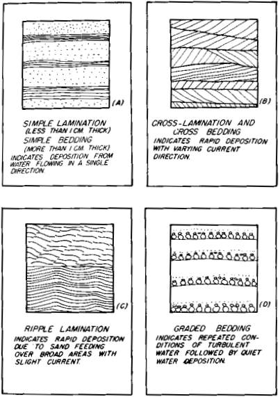
Figure 1. Types of Stratification (cross-section view, one-half actual size). These types of stratification which are very common in sedimentary rocks provide evidence of rapid deposition and can be easily understood in terms of the Flood.
Simple lamination and bedding is shown in Figure 1-A. This is the
most common type of stratification, yet one of the least well understood.
Alan V. Jopling of the University of Ontario has suggested that simple
lamination and bedding were deposited very rapidly.
The temporal significance of lamination and bedding deposited subaqueously in granular cohesionless materials is not so readily evaluated as it is for the case of cross-lamination and cross-beds, that is, sediment transport principles are more difficult to apply. It is probable, however, that the rate of deposition is of the same order of magnitude as cited previously (seconds, minutes, and possibly hours).9
Cross-lamination and cross-bedding are shown in Figure 1-B and are
produced by wind or flowing water. Jopling suggests that water-deposited
cross-laminae which are one-eighth to one-quarter inch thick should form
in a period of a few seconds. He calculates that single cross-beds form
in the Mississippi River in a period of less than one minute. At these
very rapid rates of deposition, Jopling suggests that cross-bedded deposits
over thirty feet thick may have accumulated in only a few days. Cross-bedding
therefore provides evidence of very rapid deposition, far greater than
uniformitarian estimates of the average rate of deposition.
Probably the most conclusive evidence that stratification can be produced
by flood conditions comes from ripple lamination which is shown in Figure
1-C. Ripple lamination is common in sedimentary rocks. Often what is a
massive and apparently structureless rock to the eye shows ripple lamination
in X-ray photographs. The chief significance of ripple lamination is that
sediment must have been introduced in abundance over a wide area with a
strong water current. Ordinary stream conditions do not feed sand over
a wide enough area to produce the lamination. Flood conditions, however,
are ideal for the formation of ripple lamination and it has been found
extensively due to intermittent flooding in the flood plains of large rivers.
Edwin D. McKee who is the world's foremost authority on ripple lamination
summarizes his work as follows:
The chief significance of ripple lamination in the geologic record is that it is an indicator of environments involving large and rapid sand accumulation. Ripple marks on most tidal flats and beaches or in comparable areas where addition of new sand normally is at a slow rate, have little chance of developing into superimposed ripple lamination (i.e., climbing ripples or ripples-in-phase). In contrast, areas in which sand accumulates periodically but rapidly, as in river flood plains where sand-laden waters of strong floods suddenly lose velocity, are very favorable for building up ripple-laminated deposits.10
Graded Bedding
The term graded bedding refers to a type of stratification where
each stratum displays a progressive decrease in the coarseness of grains
from the base to the top (see Figure 1-D). The base of each bed may range
from fine sand to coarse gravel. The top of each bed usually contains fine
silt and clay with an absence of coarser material. Dunbar and Rodgers comment:
The individual beds range from a few tenths of an inch to several feet thick, and they may build up great thicknesses of rock, even thousands of feet, characterized throughout by a monotonous repetition of coarse and fine materials, with the gradation always in the same sense. . . . The beds are generally even, commonly remarkably so, and individual beds appear to have extraordinary lateral extent, locally even miles. . . .11
Dunbar and Rodgers admit the difficulty of attributing graded bedding
to conventional, modern-day processes of sedimentation.
A reasonable explanation of graded bedding in terms of the standard processes of stream or shallow-water deposition has proved difficult. The facts seem to demand that material be dumped suddenly yet fairly evenly over a large area and then allowed to settle quietly in accordance with size, coarser before finer, undisturbed by scouring currents, and that the dumping be endlessly repeated though separated by intervals of complete quiet. On the other hand, those currents in streams or in shallow seas that are capable of handling material as coarse as much of the material in the graded beds produce a totally different arrangement; they sort the material better and ordinarily separate widely the coarser and finer particles, and moreover they rarely place coarse material directly on top of fine without obvious scour. In addition they regularly produce coarse cross-stratification, which is rare in association with graded bedding.12
Within the past twenty years studies have shown that graded bedding
can be caused by a submarine landslide of loose sediment called a turbidity
current. If the sea bottom slope is steep enough, the sediment builds up
speed and becomes mixed in water forming a highly turbid, relatively dense
and viscous mass of moving fluid. A turbidity current may carry such an
enormous amount of suspended sediment at such great speeds that when the
bottom slope becomes flatter, the sediment spreads out and is deposited
over an area of thousands of square miles. The coarse material is first
to be deposited followed by a progressive decrease in the coarseness producing
a graded bed.
One commonly cited evidence of the turbidity current origin of graded bedding is the Grand Banks earthquake (November 18, 1929) south of Newfoundland which caused a turbidity current which broke many transatlantic cables. Twelve of the cables broke at different distances up to about 460 miles from the origin of the current. Since the exact time of breakage of each cable was recorded, the speed of the turbidity current could be determined. The speed was calculated from the data twenty years afterwards and was estimated to have reached a maximum of about sixty miles per hour. Core samples taken of the sediment showed graded bedding. The sediment was estimated to cover about 100,-000 square miles of ocean floor.
The role of turbidity currents in depositing graded bedding was upheld by Ph. H. Kuenen and C. I. Migliorini who in their classic experiments produced graded bedding by generating an artificial turbidity current.13 Observation in fresh water lakes and study of marine sediment core samples has also supported the turbidity current theory.
What does all the talk by geologists about turbidity currents mean? Basically it is a subtle admission that everyday, conventional processes of nature are not satisfactory to explain large portions of the Stratigraphic record. Geologists are acknowledging that spasmodic and semicatastrophic events are important geologic processes. Turbidity currents have certainly deposited a graded bed several feet thick in only a few hours. Since thousands of feet of strata are composed of graded bedding, the rate of deposition must have been very rapid. Obviously the theoretical average rate of sedimentation (one foot every 2,000 years), which is based on uniformitarian assumptions, is here greatly in error. Also, a single turbidity current deposits sediment over areas of many thousands of square miles. The monotonous repetition of graded bedding indicates that turbidity currents frequently recurred. They must have been of major geologic and global significance.
It is noteworthy that the Flood would have generated turbidity currents as well as conditions very similar to turbidity currents. The waters of the Flood would have stirred up a heavy and viscous load of sediment. When the turbidity of the waters decreased, very rapid deposition would have occurred over vast areas. Minor oscillations in current would have introduced new sediment which could have been deposited on previous beds producing the characteristic repeating graded beds.
Daniel J. Stanley discounted the turbidity current origin for the graded bedding of some southeastern Massachusetts rocks. He considered periodic flooding of streams over broad flood plains as the cause. Several similarities between flood and turbidity currents were noted.
Flood and turbidity currents have much in common: (a) flows may appear suddenly in a foreign environment; (b) flows are characterized by high discharge, velocity, turbulence, and load; (c) the sediment load comprises a wide range of size grades; (d) currents are able to erode the bottom and remove scoured material; and (e) the sediment load is released progressively as the intensity of the flow decreases, away from the source. The resulting beds are graded vertically and laterally. Similar deposi-tional processes active in environments as different from each other as flood plains and marine slopes and basins can produce similar assemblages of sedimentary structures.14
Coal
The very familiar substance called "coal" is mostly the carbon remains of accumulated and altered plants. Coal is commonly stratified and found interbedded with clay, shale, limestone, or sandstone. Beds of coal vary in thickness from a fraction of an inch to several tens of feet. Single strata of coal are known to be laterally continuous over many thousands of square miles. In some localities coal strata repeat as many as a hundred times in a vertical section.
Two theories have been proposed to explain the formation of coal. The widely held theory by many uniformitarian geologists is that the plants which compose the coal were accumulated in place in large fresh-water swamps or peat bogs over millions of years. A second theory proposes that the vegetation was rapidly transported and deposited under flood conditions forming the coal strata.
It is significant that while uniformitarian geologists maintain that most coal formed in swamps, they also acknowledge that some coal is due to transport and deposition. These geologists will admit with reluctance the water-borne origin of coal only when the evidence demands it.
Some evidence which supports the transported and deposited origin of coal is presented below:
(1) Coal in many locations is known to have accumulated very rapidly. Upright tree trunks frequently greater than ten feet in height have been found in coal beds. The coal forming plants must have amassed to cover the tree before it could rot and fall down. Other upright trees are not rooted in soil and must have been transported. Rarely these trees are positioned with their tops downward in the coal and so could not have grown in place. It is hard to imagine how such a thickness of coal could have accumulated in such a short time according to the growth-in-place theory.
Also, the extraordinary preservation of plant material (leaves, seeds, cell structure of wood, etc.) is a general characteristic of coal, indicating rapid burial.
(2) Coal appears to constitute a regular part of the sedimentary series. Beds of coal are commonly associated above and below with transported material. Coal is often abruptly succeeded by distinctly marine rocks with marine fossils without any intervening transition of brackish-water deposits. A gradual change in salinity would be expected if coal formed in great fresh-water swamps or bogs.
A coal seam followed laterally sometimes splits into two seams separated by transported marine sediments indicating that the deposition of coal and the associated marine sediments was coeval. There is no sign of beach deposits between the marine formation and the coal as the growth-in-place theory would need.
Coal beds usually show bedding similar to many sandstones which are of transported origin. Often coal shows slight laminations in color and parts on certain planes like shale which is of transported origin. Simplicity would suggest that coal was transported.
(3) Marine fossils have been found in coal:
The small marine tubeworm, Spirorbis, is abundant in the fossil record. No member of this genus is found in a fresh-water habitat. Since Spirorbis tubes are found as a constituent of Carboniferous coal, they are strong evidence for the allochthonous, or transported, origin of much of the coal. This is contrary to the presently popular view that coal originated in swamps and marshes due to the accumulation of plant materials over long periods of time.15
These marine tubeworms probably became attached to the drifting
coal-forming plants.
Within some coal strata rounded masses of matted and exceptionally
well-preserved plant or animal fossils have been found cemented with mineral
matter. These masses have been called "coal balls." Various types of marine
animals including sponges, corals, and mullusks have been found in coal
balls.16 The mineral cement of coal balls also
requires a salt water environment for formation.17
(4) The absence of any type of soil below many coal beds shows the impossibility of any type of luxuriant vegetation growing in place and argues for a transported origin.
(5) The presence of Stigmaria, a root-like plant fossil often found below coal seams, has been considered by some specialists to be unambiguous proof of growth-in-place. (These fossils are thought to represent the roots of trees preserved where they grew.) However, N. A. Rupke18 at Princeton University examined several outcrops in Nova Scotia and found that many Stigmaria were only fragments and not attached to any tree. Moreover, Stigmaria in each sampling location showed preferred orientation, an evidence of current action during deposition. From these and other observations Rupke concluded that the Stigmaria he sampled and their enclosing rock were transported and deposited. Rupke's work brings serious question on the growth-in-place interpretation of other Stigmaria-bearing beds.
(6) For more than a hundred years the occurrence of boulders in European and North American coal strata has been known. In the Sewell Coal of West Virginia many erratic boulders have been found. P. H. Price collected 40 boulders, the average weight was 12 pounds and the largest weighed over 160 pounds. Most of the boulders are "unlike rocks known to occur in West Virginia."19 The nearest possible source for some of the rocks is 60 miles away. These boulders must have been transported, probably by being entwined in the roots of trees and drifted to their present location. The growth-in-place theory for the origin of coal fails to explain the evidence at hand.
(7) Examinations of modern peat bogs and swamps has failed to show any locality where plants are accumulating and have produced coal beds. According to the Principle of Uniformity we should be able to find a modern example of coal forming.
In summary, the Flood origin of coal seems to be well supported. There is good reason to believe that much of our coal has been transported and deposited rather than accumulated in place. The question is important and needs further study.
Dolostone
Dolostone is the rock composed primarily of the mineral dolomite which has the chemical formula CaMg(CO3)2. Ancient carbonate rocks contain abundant stratified dolostone bodies. In places dolostone beds thousands of feet in thickness underlie many thousands of square miles of the earth's surface. In contrast, recent sediments consist almost entirely of the minerals calcite and aragonite, both CaCO3, which is thought to be forming the rock called limestone. The mineral dolomite, CaMg(CO3)2, is nearly lacking in modern sediments. The striking contrast between the composition of ancient carbonate rocks and recent carbonate sediments presents a problem of first magnitude. In their discussion of dolostone Dunbar and Rodgers begin with a remarkable admission:
Although dolostone is by no means uncommon among the sedimentary rocks of the geologic record, its origin is still uncertain. Probably the chief reason for this uncertainty is that, unlike the other major types of sediments, it is nowhere known to be forming today, and therefore the present fails us as a key to the past.20
Dolostone is not forming today. The discrepancy in the Principle of Uniformity is evident. (If the principle were correct on this point, there should be a present-day example of dolostone forming')
Geologists have expressed strongly opposing views as to the origin of dolostone. One theory attempts to explain dolostone as the result of replacement. Many deposits show evidence that the rock was originally limestone and that water rich in magnesium has dissolved the limestone replacing it with dolostone. One of the most compelling evidences of replacement origin is that no organism today secretes dolomite, yet we find extensive shell beds which are entirely dolostone.
While some dolostones are the result of replacement, others seem to have been directly precipitated from water. Some dolostones have extremely delicate and well-preserved primary sedimentary structures such as simple lamination, ripple lamination, small scale cross-bedding, graded bedding, drying cracks and fossils. If replacement had occurred, most of the structures would be obliterated. Many of the laterally extensive dolostones are underlain and overlain by limestones that show no alteration. The contacts between beds of dolostone and limestone are sharp and well defined. If replacement had occurred the contacts would be expected to show alteration. Strata of dolostone which are laterally persistent for thousands of miles can be best explained by direct precipitation.
Having no present-day example of dolostone forming by direct precipitation, we are free to speculate within the limits of simplicity. Could the Flood account for direct precipitation of dolostone? The waters of the Flood could have been highly concentrated with calcium and magnesium carbonate and could have easily precipitated a great quantity of dolomitic sediment. The delicate primary structures and laterally persistent strata could be most simply explained by the Flood.
Chert
Chert is a hard and usually structureless rock composed almost entirely of micro-crystalline silica (SiO2). It occurs in nodules, often called "flint," which are a few inches in diameter, and as very extensive stratified beds from an inch to fifty feet or more in thickness. Our consideration of chert will deal with bedded chert since nodular chert does not form a significant part of the Stratigraphic record.
The major problem encountered in investigating the origin of chert is that no chert is forming today. According to the Principle of Uniformity there should be a present-day example. Dunbar and Rodgers note:
Chert has been the subject of as much controversy as dolostone, and for about the same reasons: neither is known to be forming anywhere today, and the chemistry of formation of each presents difficult problems.21
Three important theories have been proposed to explain the origin of bedded chert. The first suggests that chert was formed by replacement of non-chert rock by migrating silica-bearing water. The second theory proposes that chert was biochemically derived by small organisms which secrete silica. The third theory suggests that chert was directly precipitated from sea water and deposited as a silica gel.
What is the status of each of these theories among geologists? The first
theory, which suggests that replacement was important in chert formation,
has not been widely accepted. F. J. Pettijohn says:
The extraordinary thickness of these deposits and their great areal extent make it difficult to consider them merely a replacement of limestone or other carbonate rock. . . . The uniformity and rhythmic nature of the bedding and the absence of evidence of replacement make the hypothesis of a metasomatic [replacement] origin unlikely.22
The second theory which proposes that bedded chert was biochemically
formed has also run into difficulties. Some bedded cherts have no traces
of any organism which could have precipitated the silica. When fossil silica-secreting
organisms are found they are usually in such a perfect state of preservation
that the surrounding microcrystalline chert could not be made from these
organisms.
Minute fossil forms are often found in cavities of the chert and are usually in a remarkable state of preservation, which is a point of much significance in the matter of origin as it shows rapid burial.23
A few bedded chert deposits, however, may be biochemically derived.
The third theory which proposes that chert was precipitated directly
as a silica gel has been widely accepted. The data seems to fit this theory
the best. Pettijohn says:
The origin of the bedded cherts is a very controversial subject; many theories to explain these deposits have been advanced. . . . Most students of bedded chert, however, reject both the biochemical and the metasomatic [replacement] origins for these deposits and regard them as primary precipitates of silica gel.24
Yet those who hold the theory that chert was directly precipitated
as a silica gel cannot hold strictly to the Principle of Uniformity because
no bedded chert is forming today by precipitation! Critics of the
direct precipitation theory have pointed out the impossibility of silica
being flocculated by any known agent even in water with a silica concentration
many times greater than that of our present oceans.
If modern conditions cannot precipitate silica, could the Flood provide conditions for direct precipitation of silica gel? Yes, if a widespread flood occurred, the water could have been highly saturated with silicates and conditions would be ideal for flocculation of silica. Both rapid and widespread deposition would also be possible and is in agreement with evidence.
Conglomerate
Another indication that great amounts of sediment were deposited under
flood conditions comes from the study of conglomerate. This type of rock
is composed of cemented gravel and pebbles. Conglomerate is common in the
Stratigraphic record occurring in deposits ranging from isolated lenses
to strata which cover thousands of square miles. Often the base of sandstone
strata contain coarser sand with gravel and pebbles.
One of the most thoroughly studied conglomerate formations is the Shinarump
of the Colorado Plateau.
The Shinarump conglomerate and recognized equivalents outcrop over wide areas in northern Arizona and southern Utah and less extensively in central, northern and western Utah, western Colorado, northwestern New Mexico, southeastern Nevada, and southwestern Idaho. Its total original areal extent exceeded 125,000 square miles. It is usually less than 50 feet thick but may locally reach 300 feet.25
Composing the Shinarump conglomerate are pebbles of varicolored
quartz and quartzite, limestone, chert, and petrified wood with much sandstone
and shale in lenses. Large petrified logs have also been found in the conglomerate.
Huge cross-bedding is common even in the coarsest material. Herbert E.
Gregory comments:
The unsolved problem of Shinarump lithology is the source of the pebbles in the conglomerate. The slabs of sandstone and clay balls may have come from underlying beds, the cycads doubtless grew where their fossils are found, and the petrified trees are probably driftwood. . . . But no Triassic or Carboniferous formation so far mapped includes material that might supply the varicolored quartz and quartzite.26
From where did these quartz and quartzite pebbles come? Strata which
immediately underlie the Shinarump do not have pebbles of this character.
Erosion of underlying rocks seems to have not been the source of these
pebbles. Apparently these pebbles were transported great distances to their
present location.
Under what conditions did the Shinarump
conglomerate accumulate? An example
of such a present-day widespread conglomerate
in the process of formation has not been found.
The physiographic conditions under which the Shinarump was deposited are difficult to visualize. What conditions could be so persistent and so uniform as to permit the deposition of a thin sheet of material essentially alike over thousands of square miles in Utah, Arizona, and Nevada?27
Could streams deposit the vast blanket of coarse material or could
flood conditions? The common unsorted texture of the conglomerate with
mixed sand and pebbles is not normally produced by streams. Sand and pebbles
are usually separated by the stream and not deposited together. Turbulent
and flowing water, however, can easily deposit coarse material with sand.
The very large cross-bedding in very coarse material is not deposited by
present day streams. Very strong currents are necessary. If streams deposited
the conglomerate, why is not the rock underlying the Shinarump deeply channeled?
Streams also do not normally transport coarse pebbles hundreds of miles
over fairly level surfaces of deposition. Flood transport and deposition
seem to be a reasonable mechanism for forming the Shinarump conglomerate.
There is evidence of conglomerate "blankets" even more extensive than the Shinarump. Evidence will be presented later of an unsorted stratum of conglomerate thought to have been widespread over most of western North America. If a blanket of this dimension existed it would certainly be difficult to explain by normal stream processes.
Graywacke (greywacke)
The term graywacke is used to denote a type of sandstone with rock or mineral fragments in a dominant, grayish "clay" matrix. The unsorted character of graywackes with larger often angular fragments in the dark fine-grained matrix is easily distinguished from other sandstones. Graywackes commonly have graded bedding but some show cross-bedding. They are worldwide in their occurrence (about 10 to 15 per cent of all sandstones are graywackes ).
Explaining the origin of graywacke has been perplexing to uniformitarian
geologists. The first problem concerns the origin of the graded bedding.
Pettijohn wrote in the first edition of his book, Sedimentary Rocks,
concerning graywacke:
Very rapid deposition is implied by the muddy matrix (indicating thereby a lack of sorting), by the massive and nonstratified nature of the thicker beds; by the lack of cross-bedding and ripple marks (which are the evidence of reworking and sorting and are possible only if the sedimentation is not too rapid); by the graded bedding of some phases (each graded bed possibly representing a single year's accumulation); and by the extraordinary thickness of sedimentary deposits characterized by graywackes.28
In his second edition Pettijohn recognized that turbidity currents
may have deposited the graded beds. Instead of considering each graded
bed as the result of a "single year's accumulation" (first edition) he
proposed that each was the record of a "single semicatastrophic event"
(second edition). His words in the second edition were:
If the theory of deposition of graywackes by submarine-generated turbidity flows is correct, it is clear why such deposits have never been observed to form despite the fact that graywackes are a relatively common type of sandstone found in all geologic ages. Each graywacke bed is the record of a single semicatastrophic event — a short-lived episode which is completely hidden from ordinary observation.29
Not all graywackes can be the result of turbidity currents. Some
graywackes have large-scale cross-bedding which indicates that strong flowing
water currents were involved in the formation of the beds. It is evident
that average conditions which are presently observed are inadequate to
explain the origin of the graded structure of graywackes. Some type of
catastrophic or semicatastrophic sedimentation mechanism must be involved.
A second problem with graywacke concerns the origin of the unsorted
character (the larger fragments in the fine-grained matrix). A great deal
of research has been done on modern turbidity current deposits but none
of these sediments is a graywacke. W. A. Cummins said:
A major difficulty with any hypothesis involving a detrital origin for the characteristic greywacke matrix is the failure to find a modern sediment of greywacke type.30
Nowhere has a graywacke sediment been found. According to the Principle
of Uniformity the present-day sediment should exist. This failure of the
Principle of Uniformity bothered Cummins.
The mode and environment of deposition of greywackes can be inferred from their sedimentary structures and from their litho-logical and paleontological associations. Thus many are found to be deep water marine turbidites; others are shallow water marine sediments; and yet others are fluviatile. Modern sediments of comparable origin whether found in nature or deposited experimentally, are not greywackes. Thus if the Principle of Uniformitarianism is applied, the peculiar texture of greywackes cannot be an original detrital feature, but must be the result of post-de-positional alteration of "normal sand." If this is so then the greywacke problem is a problem, not of sedimentation, but of post-depositional cementation.31
Cummins' reasoning is a splendid example of how the Principle of
Uniformity is used to interpret the geologic data! To avoid contradiction
with the sacred doctrine, he claims that the texture of graywacke is not
due to original sedimentation but caused by alteration after deposition.
We could ask: Where is the sediment which is in the process of alteration
to graywacke? There should be a present-day example. Among sedimentary
rocks graywacke is very unstable. Why has alteration stopped at graywacke?
Why are not all our graywackes altered to some other rock? Uniformitarian
explanations fail to account for the problem at hand.
Evaporites
The class of rocks called evaporites are formed by the precipitation of various salts directly from concentrated solution. The common minerals which comprise evaporites are gypsum (CaSO4.2H2O), anhydrite (CaSO4), and common salt (NaCl), often called halite. Evaporite beds are frequent in the Stratigraphic record and sometimes are thousands of feet in thickness.
The origin of evaporites is a very controversial subject. The traditional
approach, which assumes the Principle of Uniformity, has attempted to explain
their origin by the same processes which we observe today. As the name
implies, evaporites are thought to form due to the evaporation of ocean
waters, in small seas often called "basins." When the waters become a fairly
concentrated brine, deposition of the various evaporite minerals is thought
to occur. The deposition of thick evaporites is thought to take millions
of years. Pettijohn discounted the hypothesis that evaporites are deposited
simply by the direct evaporation of sea water.
Inasmuch as many evaporite deposits show marked exceptions to the above requirements, simple evaporation of sea water did not occur and either the parent brine was not formed from sea water or the evaporation took place under special conditions that will explain the anomalies.32
The thickness and purity of evaporite beds are hard to explain.
How could evaporite solely be deposited over a period of many thousands
of years without a visible trace of other chemical sediments such as limestone
and without land-derived sediments such as wind-blown sand? If evaporite
was deposited rapidly due to a mechanism other than concentration
by evaporation, the thickness and purity could be easily explained.
Some geologists have questioned the idea that evaporites were deposited
in small separate seas or "basins." The very qualified stratigrapher Harry
E. Wheeler says:
The generally accepted notion that Silurian evaporites were generated in a few isolated "basins" such as the Michigan Basin and its presumed counterpart in Ontario-New York is without basis in terms of integrated stratigraphy. Like so many paleogeologic interpretations, this one is based primarily on present structural and preservational patterns.33
Wheeler believes that many evaporites were deposited as very extensive
interregional "blankets." There is no example of such widespread layers
forming today.
The conditions which were responsible for the deposition of evaporites are still a mystery. Perhaps the name "evaporites" is itself misleading. The formation of evaporites may have nothing to do with evaporation.
Redbeds
The term redbeds denotes a rock group whose chief unifying characteristic is the presence of a red coloring pigment of iron. Sediments which compose redbeds have a wide range in coarseness from silt through sand to gravel. Redbeds are very important in the Stratigraphic record and are found throughout the world. In the Colorado Plateau and Rocky Mountain regions redbeds cover several hundred thousand square miles. Their thickness is commonly several thousand feet.
Geologists have held widely divergent views as to the origin of redbeds.
A major problem is explaining the red coloring matter. Since redbeds are
commonly associated with evaporites, some geologists have thought that
redbeds formed in an arid, perhaps desert environment. However, Dunbar
and Rodgers note:
The association of some redbeds with large deposits of evaporites, and locally of dunes, influences many of the earlier workers in geology to consider redbeds as the product of an arid or at least semiarid environment. On the contrary, with the exception of areas where the soil and mantle are derived from underlying redbeds, the deserts are notable for their dun and buff colors; they are not red.34
One geologist considered most of the redbeds of the Rocky Mountain
region to be marine. His conclusion seems well founded:
Most of the red beds are marine in origin. They have the following diagnostic characteristics: (1) even bedding, (2) persistent beds, (3) sediment well sorted, (4) beds extensively ripple marked, (5) a great deal of thin bedding; (6) extensive gypsum beds in many places, (7) many extensive limestone beds, (8) no fossils of land animals, (9) no grading from subaqueous to sub-aerial sediments.35
The Shinarump conglomerate of the Colorado Plateau is associated
above and below with very widespread redbeds in which ripple lamination
is common. The redbeds of the Painted Desert above the Shinarump have petrified
logs. The Shinarump as well as the redbeds immediately above and below
have been interpreted by many geologists as being "flood plain" deposits
formed by the intermittent "sheet flooding" of streams over the Colorado
Plateau. Might these strata be better understood in terms of the Flood?
The Sequence Concept
We have briefly considered some rather localized evidences of the Flood. Another matter is also important. Is there widespread evidence of the Flood? More than 70 per cent of the continents are covered with sedimentary rocks. Do the strata in their general distribution and association bear testimony of the Flood?
Some of the greatest progress in geology during the past twenty years has come as a result of recognizing strata solely as rock units. It may sound absurd to imply that geologists have not properly distinguished layered rocks as rock units but it is nevertheless true. Geologists of former generations have chiefly classified the strata by the fossils which they contain. The favorite method used to correlate and date rock strata, especially from one region to another has been with fossils rather than using lithologic evidence. The "rules" for correlating and dating strata were not developed in North America but were adopted from Europe over one hundred years ago. The method assumed that the order of the fossils in certain German and British strata would be the same as in the North American strata and in those of the rest of the world. The use of fossils in this manner has been moderately successful, but has led to many difficulties. In the effort to analyze interregional Stratigraphic patterns, the use of fossils has led to much confusion.
For many years, geologists have recognized the existence of widespread
physical Stratigraphic patterns. In many regions of the United States recent
well drilling data has greatly augmented Stratigraphic knowledge. L. L.
Sloss at Northwestern University said:
These broad-scale correlations have long been apparent to investigators engaged in interregional studies, and it is noteworthy that the correlations are recognizable in spite of the complex regional differences in nomenclature and description and in the face of the apparent paradoxes introduced by a classical interpretation of the paleontologic record.36
What are some observations which have recently led to the appreciation
of widespread Stratigraphic patterns? Six generalizations are significant:
(1) Many strata of sandstone (and a few strata of conglomerate) are remarkably widespread. Sometimes they are traceable at the surface many hundreds of miles. This is the most obvious evidence of widespread Stratigraphic patterns. Some strata of limestone and a few strata of shale are also very widespread.
(2) A single widespread sandstone stratum in different locations usually rests directly on top of a variety of different types of other strata. In one location the sandstone stratum may rest on limestone, in another location the sandstone stratum may rest on shale, in another location the sandstone stratum may rest on chert. (Stated more exactly, sandstone strata generally differentially truncate preceding strata.)
(3) The strata which rest directly on widespread sandstone strata are usually fairly widespread. In the western and eastern United States sandstone strata are commonly overlain with shale. In the central United States sandstone strata are commonly overlain with limestone.
(4) Some types of strata are not commonly widespread, but restricted in extent. The best example is chert (although some limestone and evaporite beds are local in their occurrence).
(5) A stratum restricted in extent is commonly underlain entirely by the same type of strata. Chert is commonly underlain entirely by limestone strata which are fairly restricted in extent.
(6) A stratum restricted in extent is sometimes overlain with sandstone or other stratum which have very widespread extent. Chert is often overlain with widespread sandstone.
What do these Stratigraphic generalizations suggest? Probably the explanation can be most easily conveyed by the use of an illustration. Figure 2 (below) shows a generalized cross section of some strata in the eastern United States. Notice that there is an angular relationship among the strata above and below the wavy line. The horizon of angular relationship which separates two Stratigraphic units is called a discontinuity or unconformity. The two strati-graphic units are called sequences. The horizontal strata above the discontinuity compose one sequence and the warped strata below the discontinuity compose the other sequence.
Figure 2
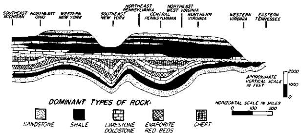
Figure 2. Generalized Paleogeologic Cross-section showing strata of the Piankasha Sequence (Latest Early Devonian to Earliest Late Devonian) resting on strata of the Tutelo Sequence (Silurian to Early Devonian). Could the Flood be responsible for depositing these vast "blanket-like" Stratigraphic patterns? (Modified from drawing by Harry E. Wheeler, "Post-Sauk and Pre-Absaroka Paleozoic Stratigraphic Patterns in North America," Bulletin of the American Association of Petroleum Geologists Vol. 47, p. 1499.)
Both sequences at their bases are composed of widespread sandstone
strata. Notice how the basal sandstone of the upper sequence differentially
truncates strata below. The sandstone in different locations rests with
an angular relationship on chert, limestone, evaporite and shale. Strata
above the widespread basal sandstones of both sequences are also widespread
and parallel to the sandstone. The upper portion of the lower sequence
is composed of chert which is fairly restricted in its extent, being underlain
by fairly restricted limestone and overlain by widespread sandstone.
Our generalizations suggest that stratified rocks may be assigned to
sequences which are bounded by discontinuities. Some very basic conclusions
follow from the above discussion.
Each sequence represents the preserved record of an essentially continuous period of deposition, often on an interregional scale. (A sequence does not represent the total sedimentary record that was once deposited, but only the preserved record.) The nearly identical physical characteristics of the stratigraphic order over wide areas indicates that many sequences accumulated in widespread and similar successions of environments.
The most fully preserved portion of a sequence is usually the thickest part. In the lower sequence in Figure 2, chert is only present in the thickest portions of the cross section. The three occurrences of chert in Southeast Michigan, Southeast New York, and Pennsylvania and West Virginia can logically be interpreted to be remnants of :a once widespread and continuous strata of chert.
The horizons of angular relationship called "discontinuities" which separate sequences represent a period of degradation or removal of a portion of the total record. Degradation is differential with respect to strata but removes them from the top down. Sometimes a sequence may be entirely removed in a location as is the case with the upper sequence in Figure 2 in eastern Tennessee. The basal portion of any sequence is the most widely preserved, and the least widely preserved is the uppermost portion. If an upper strata of a sequence is found, all underlying strata of the sequence must also be present. Warping of the lower sequence in Figure 2 must have occurred before the succeeding sequence was deposited.
Pan-Continental Blanket Sandstone
The development of the sequence concept has led to the appreciation of widespread Stratigraphic patterns. Probably the best example of a widespread pattern is the Middle Ordovician sandstone body which correlates with the well-known St. Peter sandstone of the central United States. It is composed of pure well sorted quartz sand and forms the base of a sequence which is found continent-wide. This sandstone is known to occur in various amounts in at least the following twenty-two states: California, Nevada, Idaho, Utah, Montana, Wyoming, Colorado, North Dakota, South Dakota, Kansas, Oklahoma, Missouri, Arkansas, Wisconsin, Illinois, Michigan, Indiana, Kentucky, Tennessee, Ohio, Pennsylvania and Vermont.37 It is also known to occur in Canada.
According to the Principle of Uniformity we should be able to find a
present-day example of a blanket sandstone forming. Widespread sandstones
are common in the Stratigraphic record, and they should be found today.
No modern example has been found. To transport sand thousands of miles
requires special conditions. Sand is not transported without substantial
current. Streams deliver much sediment to the ocean, but sand is always
first to settle out at the mouth of the stream, often forming a delta.
Wind can transport large quantities of sand, but produces characteristic
cross-bedding and not simple stratification over wide areas. Turbidity
currents could spread sediments over fairly wide areas but would deposit
unsorted material in graded beds. Also, a broad and level, or uniformly
sloping surface of deposition is needed, an example of which is difficult
to find today.
Widespread flood conditions, however, could easily account for blanket
deposition. Broad surfaces of deposition would be caused by beveling of
preceding un-consolidated strata by flowing water currents.
Unsorted Blanket Conglomerate!
The most recent sequence of the Stratigraphic record has a base chiefly composed of a remarkable unsorted conglomerate widely distributed over western North America. It is a Late and Middle Miocene blanket known to occur in New Mexico, Colorado, Wyoming, Utah, Kansas, Nebraska, South Dakota, Montana, Alberta and Saskatchewan.38 Subangular cobbles and boulders of limestone, gneiss, and granite in a highly cemented matrix of silt make this conglomerate unique in the Stratigraphic record. Bones of vertebrates are rare, but where found show abrasion due to water transport. A westerly source for the entire conglomerate is indicated by the coarser material to the west. Perhaps the Pacific Ocean was the source of both the rock material and the water. The importance of unsorted conglomerates has already been discussed. They indicate the presence of flood conditions. Present-day geologic processes do not deposit strata of fine sand with large boulders. Streams separate the boulders from the sand. Very turbulent and flowing water has the ability to carry both fine sand and boulders and deposit them in stratified deposits. The existence of widespread unsorted conglomerate offers further evidence of catastrophe.
Evidence of a Widespread Chert Blanket
In Figure 2, isolated chert is shown to be present in southeastern Michigan,
Southeastern New York, and in Pennsylvania and West Virginia. These three
occurrences of chert are best interpreted to be the preserved remnant
of a once continuous stratum of chert. Other fairly isolated bodies of
chert or "cherty" rock in the same Stratigraphic position are common throughout
the eastern and central United States, occurring in Illinois, Missouri,
Oklahoma, Arkansas, Tennessee and Mississippi.39
Wheeler says:
Although the Early Devonian cherty strata are widespread in their total distribution, the individual occurrences are vastly fewer and generally less continuous than the beds of the next-following Pi-ankasha Sequence.40
All of these preserved occurrences of chert supply evidence of past
deposition of a widespread blanket of chert. Yet no chert is being deposited
today! Here is a geologic problem of first magnitude. The Flood seems to
be a reasonable explanation for the deposition of widespread chert blankets.
Internal Characteristics of Sequences as Evidence of Rapid Deposition
As stated previously, sequences represent the preserved record of an essentially continuous period of deposition often on an interregional scale. The widespread physical similarity in the order of strata in each sequence indicates that virtually identical conditions were prevalent laterally over broad areas. Sandstones and conglomerates, which form the basal and best preserved parts of many sequences indicate that widespread flood conditions once prevailed. Other strata of sequences must have been equally widespread. Chert, which forms the uppermost and least frequently preserved part of some sequences, was also deposited as extensive "blankets."
Sequences are often thousands of feet in thickness. Does the vertical order of strata offer evidence of rapid deposition under flood conditions? Apparently it does. Many sequences have what can be called graded structure with the coarsest material at the base progressively decreasing in coarseness toward the top.
Sequence-forming sediments can be thought of as belonging to two groups — clastic and chemical. Insoluble clastic sediments include gravel which forms conglomerate, sand which forms sandstone, and silt which forms shale. Soluble chemicals include carbonates which form limestone and dolostone, sulfates which form evaporites, and silica which forms chert. Clastic sediments usually compose the bases of sequences and are in greatest quantity near the source, showing the tendency for elastics to be deposited first. The bases of many sequences are sandstone or conglomerate, the coarsest material in the sequences. Above sandstone is usually shale. The transition vertically from conglomerate to sandstone to shale should not be thought of as abrupt. The intermediate "pebbly sandstone" and "sandy shale" are usually present.
Chemical sediments in most cases were deposited above conglomerate,
sandstone and shale, and are most common away from the source. In the central
United States where sand and silt were sometimes not available due to the
considerable distance from the source, limestone forms the base of some
sequences. Many sequences which lacked silt in the central United States
have limestone directly on sandstone. It is clear that abundant limestone
was deposited in the absence of clastic sediments. Gravel, sand and silt
seem to "mask" from visibility the presence of carbonate.
Above limestone is sometimes dolostone or evaporite. Chert is often
the uppermost strata in sequences. Many cherts are impure and the term
"cherty limestone" is sometimes appropriate. The deposition of stratified
chert seems to have required the near absence of all other sediments. For
this reason chert forms the upper portion of some sequences.
An excellent example of graded structure in a sequence is the lower sequence of Figure 2 (above).
Sequences differ widely in their characteristics and it is difficult to say which features are generally significant. The upper sequence in Figure 2 seems to be in part an exception to the idea that sequences are graded. The lower strata of the sequence seem to be normal. Sandstone is at the base; shale above sandstone is very common toward the easterly source; and limestone above sandstone is very common to the west, away from the source. The upper portion of the sequence, however, shows fine material (shale) grading upward into coarse material (sandstone). At the top of the sequence is sandstone. The reversed grading can probably be attributed to the reworking of unconsolidated silt and sand of another sequence. Sediment of a sequence is removed from the top down so silt could be transported and deposited before sand.
Sequence-bounding Discontinuities as Evidence of Rapid Degradation
The discontinuities which bound and define sequences are themselves very widespread. A usually widespread sandstone strata which commonly overlies a discontinuity shows that the discontinuity was nearly a horizontal plain at the time sand was first deposited. (An important Stratigraphic principle says that strata must accumulate on horizontal or nearly horizontal surfaces.) An example of a vast plane of deposition is difficult to find today. If millions of years were taken to erode a portion of the underlying rock as some geologists think, we would expect that rock to be deeply canyoned in many areas rather than horizontally beveled. However, if flood conditions prevailed, underlying unconsolidated strata which were either horizontal or warped could be beveled by swift water currents. This process of degradation of unconsolidated sediment is called sublevation and can adequately explain widespread discontinuities.
Are There Global Stratigraphic Patterns?
We have considered evidences of some widespread Stratigraphic patterns on the North American continent. Another question follows. Can the strata of different continents be recognized to be related by objective physical criteria? Are discontinuities which bound sequences in North America in the same Stratigraphic position as discontinuities on other continents? If such patterns can be recognized, we would have evidence of deposition of sedimentary rocks on a truly global basis. It is noteworthy that Wheeler believes that intercontinental patterns do exist.41 Of course, research is only being started on this fascinating topic and much is to be learned. From what little data we have, it is reasonable to believe that global patterns do exist. The scriptural statements concerning the universality of the Flood would also lead us to believe in the existence of global Stratigraphic patterns.
"Basins" and "Arches"
The recognition of widespread Stratigraphic patterns is making several
traditional interpretations of geologic structures untenable. Geologists
in the past have commonly thought of sedimentation as having occurred in
"basins" of deposition separated by mountainous areas called "arches" which
deliver sediment to these "basins." It has been customary to speak of the
Illinois basin, Michigan basin, Appalachian basin, Fort Worth basin, Denver
basin, Cincinnati arch, Ozark dome, Wisconsin arch, etc. Much of this terminology
is inadequate to the stratigrapher because "basins" did not exist when
many of the strata were being deposited. Several examples could be cited
where the distribution of strata is oblivious to presently-existing structural
features. Strata deposited from an easterly source sometimes pass through
"arches" and appear in several separate "basins." In most cases "basins"
and "arches" are post-depositional preservational features. Wheeler says:
The first major infraction of custom here is the implied occurrence of preservational remnants of many of these successions hundreds to a thousand miles or more beyond the limits of the "province" or "basin" to which they presumably were restricted. Beyond this, however, the implications are no less portentous, for they are leading repeatedly to the eradication, in traditional terms, of numerous "established," so-called "persistent" positives and negatives such as the Cincinnati arch (see Patton, 1961), Ozark dome, Illinois and Michigan basins, Appalachia, Cascadia (Wheeler, 1960), and many others.42It is evident that geologists have viewed stratigraphy from a narrow perspective of local and regional patterns and have failed to recognize broader interregional and pan-continental patterns.
Mountains
Many mountain ranges can be shown to have been uplifted after nearly all of the Stratigraphic record was deposited. In mountainous regions degradation usually has removed most of the strata making it difficult to estimate when uplift occurred with respect to the Stratigraphic record. The Rocky Mountains, however, have small amounts of the most recent sequence on the continental di-vide at seven thousand feet. Contrary to traditional thinking, at least part of the Rocky Mountains must have been uplifted during or after the deposition of some of the most recent strata.43
The Cascade Mountains of the Pacific Northwest are also very recent. Strata of Columbia River Basalt have been found both to the east and west of the mountains, but not in the mountains. The strata do not become thinner ("pinch out") as they approach the mountains as would be the case if the basalt was deposited after the mountains were uplifted. The basalt, which forms the lower strata of the most recent sequence in the Northwest, must have been continuous across where the Cascades are now. The Cascade Mountains could not have existed when the basalt strata accumulated.
"Reefs" and "Deltas"
Another traditional misconception concerns isolated bodies of highly fossiliferous limestone. It has been customary to regard these as "reefs" which took millions of years to grow. The best example of this is the famous Capitan Limestone of Western Texas. The outcrop has the general shape of a reef. However, geologists have neglected the role of degradation, confusing the existing (preserved) Stratigraphic pattern with the original depositional pattern. The Capitan Limestone appears once to have been a broad and continuous layer.
Like the "reef" fallacy has been the tendency to call certain bodies of sandstone or shale "deltas." Two good examples are the Catskill "Delta" of New York and the Red Bedford "Delta" of Ohio. Again, many geologists have made a dogmatic assertion that the present preservational pattern is the same as the past depositional pattern. These outcrops can be best understood as widespread layers.
The earth's layered rocks yield many evidences that natural processes once acted with much greater intensity than at the present time. In many cases the deposition of the sedimentary rocks and their structures required enormous quantities of moving water. The extremely widespread strata often composed of coarse material seem to have required flood conditions to accumulate. Fossils generally testify of rapid, catastrophic burial. Several types of stratification require a catastrophic mechanism of sedimentation. Many major classes of sedimentary rocks are not known to be forming today and therefore imply circumstances of deposition different from those at present. Simplicity would suggest that the various evidences of Catastrophism be explained by a single flood catastrophe. Thus, the Stratigraphic record with its contained fossils instead of showing the evolutionary development of life and the gradual deposition of sediments over millions of years, actually bears testimony of the Flood.
Addendum
Further discussion with photos of dinosaur footprints and apparently
human footprints along the Paluxy River in Texas is contained in an essay
entitled "Fossil Tracks Along the Paluxy River in Texas" by Clifford L.
Burdick, to appear in future Symposium on Creation Series.
1 WiIliam B. N. Berry, Growth of a Prehistoric Time Scale Based on Organic Evolution, W. H. Freeman & Co., San Francisco, 1968, pp. 12, 13.
2 C. C. Albritton, Jr., The Fabric of Geology, Freeman, Cooper
& Co.,
Stanford, California, 1963, p. 263.
3 "A Scriptural Groundwork for Historical Geology," A Symposium on
Creation II, Baker Book House, Grand Rapids, Michigan, 1970.
4 Stratigraphy is the study of surface accumulated (stratified) rocks.
5 Principles of Stratigraphy, John Wiley & Sons, Inc., New York, 1957, p. 128.
6 These footprints apparently were bare-foot showing toes, ball of the foot, arch and heel. The difference in shape of left and right foot was obvious. One set of footprints was 12 inches long and had a stride of nearly five feet. The evidence that man and dinosaur lived together refutes the popular idea that dinosaurs lived and became extinct millions of years before man evolved. It is noteworthy that Genesis 1:24-26 implies that man and dinosaur were created and lived during the same day.
7 The Deluge Story in Stone, Bethany Fellowship, Inc., Minneapolis, Minnesota, Seventh Printing, 1968, p. 42 (emphasis his).
8 "A Miocene Catastrophe," Natural History, Vol. 20, 1920, pp. 18-22.
9 "Some Deductions on the Temporal Significance of Laminae Deposited by Current Action in Clastic Rocks," Journal of Sedimentary Petrology, Vol. 36, 1966, p. 883.
10 "Experiments on Ripple Lamination," Primary Sedimentary Structures and Their Hydrodynamic Interpretation, Edited by Gerald V. Middleton, Society of Economic Paleontologists and Mineralogists, Tulsa, Oklahoma, 1965, p. 83.
13 "Turbidity Currents as a Cause of Graded Bedding," Journal of Geology, Vol. 58, 1950, pp. 91-127.
14 "Graded Flood Deposits and Turbidites — Comparison and Significance," Bulletin of the American Association of Petroleum Geologists, Vol. 50, 1966, p. 636.
15 Harold G. Coffin, "A Paleoecological Misinterpretation," Creation Research Society Quarterly, Vol. 5, 1968, p. 85.
16 L. R. Moore, "Some Sediments Closely Associated with Coal Seams," Coal and Coal-Bearing Strata, Edited by Duncan Murchison and T. Stanley Westoll, American Elsevier Publishing Co., Inc., New York, 1968, p. 108.
18 "Sedimentary Evidence for the Allochthonous Origin of Stigmaria, Carboniferous, Nova Scotia," Geological Society of America Bulletin, Vol. 80, 1969, pp. 2109-2114.
19 "Erratic Boulders in Sewell Coal of West Virginia," Journal of Geology, Vol. 40, 1932, p. 70 (emphasis added).
20 Op. cit., p. 237 (emphasis added).
22 Sedimentary Rocks, Harper & Row, New York, Second Edition, 1957, p. 442.
23 William A. Tarr, "The Origin of Chert and Flint," University of Missouri Studies, Vol. 1, No. 2, 1926, p. 7.
25 W. L. Stokes, "Pediment Concept Applied to Shinarump and Similar Conglomerates," Bulletin of the Geological Society of America, Vol. 61, 1950, p. 91.
26 "The San Juan Country," United States Geological Survey Professional Paper 188, 1938, p. 49.
28 Harper & Row, New York, First Edition, 1949, pp. 253, 254.
30 "The Greywacke Problem," Liverpool and Manchester Geological Journal, Vol. 3, 1962, p. 53.
31 Ibid., p. 60 (emphasis his).
32 Op. cit., second edition, p. 483.
33 "Post-Sauk and Pre-Absaroka Paleozoic Stratigraphic Patterns in North America," Bulletin of the American Association of Petroleum Geologists, Vol. 47, 1963, p. 1510 (emphasis his).
35 E. B. Branson, "Triassic-Jurassic 'Red Beds' of the Rocky Mountain Region," Journal of Geology, Vol. 35, 1927, p. 630.
36 "Sequences in the Cratonic Interior of North America," The Geological Society of America Bulletin, Vol. 74, 1963, p. 94.
37 See Harry E. Wheeler, op. cit., p. 1507. See also L. L. Sloss, E. C. Dapples, W. C. Krumbein, Lithofacies Maps, John Wiley & Sons, Inc., New York, 1960, Map 10.
38 To date no description of this widespread conglomerate has appeared in the geologic literature.
41 Tost-Sauk and Pre-Absaroka Paleozoic Stratigraphic Patterns in North America: Reply," Bulletin of the American Association of Petroleum Geologists, Vol. 48, 1964, p. 124. ". . . many of the tectonically controlled patterns presently definable are at least trans-Atlantic in scope."
43 Marine strata which are fairly recent with respect to the entire
Stratigraphic record occur at an altitude of over 20,000 feet in the Himalayas
and at 10,900 feet in the Alps indicating the relative youth of these mountains.
For further information or to contact Baker Books regarding their other fine publications, click below:

Go to "A Symposium on Creation" Vols. 1-6 Go to Main Page of: www.creationism.org